Несколько лет назад мир облетела новость: на Марсе обнаружено озеро жидкой воды. Недавно ученые нашли на этой планете еще десятки подобных объектов, но одновременно появились причины усомниться, что это действительно озера
В 2018 году планетологи обнаружили на Марсе нечто, весьма похожее на огромное озеро жидкой воды. Теперь же исследователи нашли еще десятки подобных объектов. Похоже, что южная полярная шапка Красной планеты буквально усыпана водоемами. Если, конечно, необычный сигнал радара действительно порожден жидкой водой.
Вода в глубине
По мнению многих специалистов, на Марсе когда-то плескался океан, были реки и озера. И по сей день на Марсе хватает воды, но только в виде льда. Дело в том, что сегодня средняя температура поверхности планеты равна минус 63°С. Лишь вблизи экватора она иногда поднимается выше нуля. Тогда содержащийся в грунте лед может растаять. Но не стоить искать на Марсе лужи талой воды: при атмосферном давлении в 0,6% земного влага быстро обращается в пар. На сухой и пыльной поверхности планеты нет и не может быть водной глади.
Но три года назад СМИ взорвались заголовками: на Марсе обнаружено озеро! Правда, не на поверхности, а под полуторакилометровым слоем льда. Гипотетический водоем диаметром около 20 км и глубиной не менее метра был обнаружен вблизи Южного полюса Марса в районе, известном как Ultimi Scopuli.
На космических задворках: есть ли жизнь на краю Галактики
Марс — самая подходящая планета для поиска внеземной жизни. И обнаружение там жидкой воды — событие, безусловно, волнующее. Но как ученые сделали это открытие и насколько они уверены в своих выводах?
Разумеется, никто не бурил на планете скважину глубиной 1,5 км. Интригующие данные были получены радаром MARSIS с борта Mars Express — искусственного спутника Марса, принадлежащего Европейскому космическому агентству. Этот прибор работает так же, как любой другой радар: посылает к объекту исследования радиоволны и принимает отраженный сигнал.
Южная полярная шапка Марса сложена из водяного льда, углекислого («сухого») льда и минеральной пыли. Радиоволны проникают в нее на некоторую глубину, так что можно строить трехмерную карту ее ледяных недр. Но чем глубже находится тот или иной слой, тем слабее отраженное от него излучение. Это естественно, ведь радиоволны частично поглощаются толщей льда, через которую проходят дважды: по пути от антенны до отражающего слоя и обратно. Поэтому самый ясный и отчетливый сигнал радар получает с поверхности полярной шапки.
Однако авторы нашумевшего исследования обнаружили нечто странное. Сигнал, отраженный от некого объекта на глубине 1,5 км, был интенсивнее, чем с поверхности! Исследователи предположили, что здесь присутствует какое-то вещество, отражающее радиоволны лучше, чем лед. Какое же? Напрашивалась гипотеза, что это жидкая вода. Тем более что подледные озера есть и на Земле. Специалисты посчитали и убедились: отражательная способность воды прекрасно объясняет свойства сигнала.
Жар сомнений
Авторы открытия не претендовали на то, что существование подледного озера — доказанный факт. Они лишь утверждали, что это самая убедительная интерпретация данных. Ученые вообще, как правило, очень осторожны в выводах, и лишь в пересказах СМИ те приобретают сенсационную категоричность.
Между тем «озерная» гипотеза, при всей ее привлекательности, вызывает очевидный вопрос: почему вода не замерзла? Да, подледные водоемы есть в Антарктиде и Арктике, но на полюсах Марса гораздо холоднее. В 2019 году независимая научная группа подсчитала, что даже при самых больших концентрациях природных солей гипотетическое озеро неминуемо замерзло бы без дополнительного источника тепла. Либо это вообще не водоем, заключили ученые, либо его подогревает некая «печка». Таким обогревателем мог бы быть подземный очаг жидкой магмы, вдвое увеличивающий тепловой поток из недр Марса.
Вторые на Марсе: что означает отправка Китаем миссии на Красную планету
Но существуют ли на планете магматические очаги прямо под поверхностью? Подобное открытие стало бы не меньшей сенсацией, чем обнаружение воды. Самые свежие следы вулканизма на Марсе имеют возраст 2,5 млн лет. Правда, совсем недавно ученые зафиксировали на поверхности планеты интригующую деталь, которая может оказаться следами недавнего (50 000–200 000 лет назад) извержения. Но говорить об этом как о факте определенно еще рано.
А в 2020 году исследовательская группа, включающая многих авторов первоначального открытия, сообщила об обнаружении еще нескольких «озер» поблизости от первого. Они были открыты с помощью все того же радара MARSIS. Правда, авторы использовали новые алгоритмы обработки данных, которые обычно применяются для исследования земных ледников.
Этот результат вдохновляет, но и озадачивает. Если это все-таки вода, почему она не замерзает? Неужели подогревающий ее гипотетический очаг магмы так велик, что его хватает на несколько озер, пусть и расположенных близко друг к другу? А если не вода, то что же это?
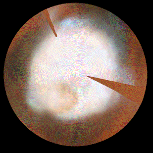
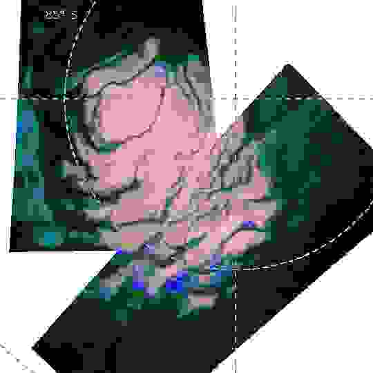
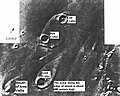
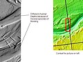
[[{“fid”:”393647″,”view_mode”:”default”,”fields”:{“format”:”default”,”alignment”:””,”field_file_image_alt_text[und][0][value]”:”Цветные точки представляют собой места, где орбитальный аппарат Mars Express ЕКА зафиксировал яркие радарные отражения”,”field_file_image_title_text[und][0][value]”:”ESA / NASA / JPL-Caltech”,”external_url”:””},”type”:”media”,”field_deltas”:{“3”:{“format”:”default”,”alignment”:””,”field_file_image_alt_text[und][0][value]”:”Цветные точки представляют собой места, где орбитальный аппарат Mars Express ЕКА зафиксировал яркие радарные отражения”,”field_file_image_title_text[und][0][value]”:”ESA / NASA / JPL-Caltech”,”external_url”:””}},”attributes”:{“alt”:”Цветные точки представляют собой места, где орбитальный аппарат Mars Express ЕКА зафиксировал яркие радарные отражения”,”title”:”ESA / NASA / JPL-Caltech”,”class”:”media-element file-default”,”data-delta”:”3″}}]]
Планета озер?
И вот недавно Адитья Хуллер и Джеффри Плот из Лаборатории реактивного движения НАСА предприняли новое исследование. Они составили трехмерную карту южнополярных слоистых отложений. Этот геологический регион включает и район Ultimi Scopuli, где были обнаружены предполагаемые озера. Эти отложения хранят климатическую историю Марса за миллионы лет, так что у ученых есть причины интересоваться ими и помимо «водного вопроса». Заметим, что ни Хуллер, ни Плот не участвовали в открытии нашумевших «озер».
Дуэт планетологов обработал данные, накопленные прибором MARSIS с 2005 года. За это время Mars Express совершил более 15 000 витков вокруг Марса, и на протяжении более чем 2 000 оборотов радар сканировал упомянутые отложения. Это позволило составить их карту с разрешением 1,5 км по горизонтали и 50 м по глубине.
Божьи мельницы: как было открыто вращение самых больших структур во Вселенной
На свежей карте авторы обнаружили десятки «подледных озер», аналогичных тому, что произвело сенсацию в 2018 году. Оказалось, что они разбросаны по всему району южнополярных слоистых отложений, куда более обширному, чем Ultimi Scopuli, и занимающему 1,6 млн кубических километров льда. Эти результаты были изложены в научной статье, опубликованной в журнале Geophysical Research Letters.
«Мы не уверены, являются ли эти сигналы [признаками наличия] жидкой воды или нет, но они, по-видимому, гораздо более распространены, чем те, что были обнаружены в исходной статье, — констатирует Плот. — Либо жидкая вода обычна под южным полюсом Марса, либо эти сигналы указывают на что-то еще».
Искатель жизни: чем уникальна новая марсианская миссия
Пока планетологам была известна лишь тесная группа «озер» в районе Ultimi Scopuli, еще можно было предположить, что они согреваются подземным теплом. Но гипотеза, что под южной полярной шапкой Марса разбросаны десятки магматических очагов, выглядит уж слишком смело. При этом многие из «водоемов», обнаруженных Хуллером и Плотом, находятся под менее толстым слоем льда, чем обнаруженное в 2018 году «озеро». Значит, они должны быть еще холоднее, и объяснить наличие в них жидкой воды еще труднее.
Похоже, что мы не знаем о Марсе чего-то важного. Возможно, там по каким-то причинам остается жидкой вода, которой положено замерзнуть. Или же вблизи южного полюса планеты есть что-то еще, что выглядит как вода на радарных изображениях. В таком случае весьма интересно было бы выяснить, что же это такое. Ответить на этот вопрос помогут только новые исследования.
Мнение редакции может не совпадать с позицией автора
Звездный путь: кто из миллиардеров побывал в космосе или отправится туда в ближайшее время
Звездный путь: кто из миллиардеров побывал в космосе или отправится туда в ближайшее время
8 фото

Гидросфера Марса — совокупность водных запасов планеты Марс, представленная водным льдом в полярных шапках, парами воды и облаками в атмосфере, льдом над поверхностью, сезонными ручьями из жидкой воды и возможными резервуарами жидкой воды и водных растворов солей в верхних слоях литосферы Марса. Гидросфера Марса, вследствие господствующих низких температур на Марсе и нахождения запасов воды в твердом состоянии, также называется криолитосферой.
Поиски воды на Марсе[править | править код]
Марс весьма схож с Землёй по многим показателям, что заставляло учёных XIX — начала XX века допускать, что на нём есть жизнь и есть жидкая вода. По мере роста объёма данных о планете, собранных различными методами, например, с помощью спектроскопических измерений, стало понятно, что воды в атмосфере Марса ничтожно мало, однако она всё же есть[1]. Прежде всего внимание исследователей привлекли полярные шапки Марса, так как предполагалось, что они могут состоять из водного льда по аналогии с Антарктидой или Гренландией на Земле, однако высказывалась и гипотеза, что это твёрдый диоксид углерода[2]. В пользу последней говорили результаты одного из первых численных экспериментов 1966 года на ЭВМ IBM 7074[3] по моделированию суточных и годовых изменений температуры на поверхности Марса в зависимости от широты и соответствующей динамики полярных шапок для случаев, когда они состоят из H2O и CO2. Авторы этой работы пришли к заключению, что полученная ими годичная вариация размера полярных шапок во втором случае гораздо ближе к наблюдаемой.
На смену астрономическим наблюдениям и спектроскопическому измерению с началом эры космонавтики пришло и прямое изучение Марса и поисков воды на нём с помощью АМС.
Так, на первых подробных изображениях поверхности Марса, полученные аппаратом «Маринер-9», можно видеть сети долин (такие как долины Нергала[4]) — элементы рельефа, свидетельствующие о присутствии в прошлом жидкой воды, в частности, подтопления грунтовыми водами склонов оврагов, поскольку они выглядят идентично эрозионным структурам на Земле, например, на Гавайских островах и в каньонах Эскаланте[en] плато Колорадо[5][6].
Помимо разветвлённой сети долин, начиная с этих ранних снимков «Маринера-9» различают[7] элементы рельефа, связанные с интенсивным разливом и называемые каналами оттока. Они выглядят как уменьшенная копия крупнейших земных дилювиальных форм. На сегодняшний день считается общепризнанной гипотеза, что происхождение этих каналов также связано именно с жидкой водой, хотя теоретически возможны и другие варианты. Каналы оттока в основном моложе сетей долин, хотя встречаются и достаточно древние образования. По всей видимости, они сформировались в период, когда условия на поверхности Марса были примерно такими же, как сейчас[8].

В конце 1990-х годов аппаратом Mars Global Surveyor были собраны топографические данные с помощью высотомера MOLA[en], на основании которых составлены полные карты рельефа поверхности Марса. Помимо многочисленных сетей долин и каналов оттока, на них хорошо просматривается район Северной низменности, и его граница — зона контакта[en] — сильно напоминает берег постоянного водоёма. В пользу гипотезы океана[en] свидетельствует то, что линия контакта практически эквипотенциальна; параллельно ей располагаются характерные террасы; заключённый внутри неё объём согласуется с оценками объёма жидкой воды на раннем Марсе; поверхность низменности гораздо более гладкая, чем её окрестности[9][10]. Впоследствии ещё одним аргументом в поддержку этой теории стал также анализ распределения элементов рельефа, подобных речным дельтам: многие из них расположены вдоль этой береговой линии, в частности, на одной и той же высоте[11].
Аппаратом Mars Global Surveyor были получены и обычные снимки, и их анализ в 2000 году подтвердил существование каналов, сформированных потоками жидкой воды, а также песка и грязевых отложений, оставленных этими потоками. Эти элементы рельефа были настолько свежими, что можно говорить о том, что они формируются и в настоящий период[12][13]. Позже наличие на тёплых склонах так называемых сезонных поверхностных линий[en][14] — темных полос, появляющихся на поверхности планеты в теплое время года и похожих на отложения солей, — было засвидетельствовано снимками камеры HiRISE на орбитальном аппарате Mars Reconnaissance Orbiter[15]. А с помощью спектрометра CRISM на его борту в 2015 году наконец было подтверждено, что они образуются на месте периодических потоков солёной воды в жидком состоянии[16][17][18]. Активные исследования сезонных поверхностных линий продолжаются[19][20], в том числе и с помощью других инструментов, например, THEMIS[en] на орбитальном аппарате «Марс Одиссей»[21].
В начале 2000-х годов с помощью гамма-спектрометра на орбитальном аппарате «Марс Одиссей» было обнаружено большое количество водорода в приповерхностном слое Марса — особенно в приполярных областях — что, скорее всего, свидетельствует о нахождении там колоссального количества (35 ± 15 % слоя по весу) воды в твёрдом состоянии[22]. Присутствие льда было подтверждено данными марсохода «Феникс», работавшего возле северного полюса планеты: белое вещество, обнаруженное на дне вырытой им небольшой траншеи, испарилось за несколько дней, что характерно именно для льда[23][24]. Аналогичный процесс был зарегистрирован аппаратом Mars Reconnaissance Orbiter и для вещества на дне свежих кратеров, в том числе и на низких широтах[25][26]. На снимках аппаратов Mars Global Surveyor, «Марс Одиссей»[27], Mars Reconnaissance Orbiter[28] и «Марс Экспресс»[29] можно видеть ещё одно свидетельство повсеместного присутствия льда в приповерхностном слое Марса — формы рельефа, напоминающие земные ледники. А радиолокатор SHARAD на аппарате Mars Reconnaissance Orbiter подтвердил, что под тонким слоем пыли и грязи в этих образованиях (в том числе в средних широтах) действительно находится лёд[30].
В 2022 году китайскими учёными были получены доказательства того, что вода на Марсе оставалась в жидком виде гораздо дольше, чем считалось ранее. Марсоход «Чжужун» обнаружил на равнине Утопия гидратированные отложения и минералы, возраст которых оценивается в 757 ± 66 млн лет, что свидетельствует о присутствии большого количества воды на Марсе в то время[31][32].
-
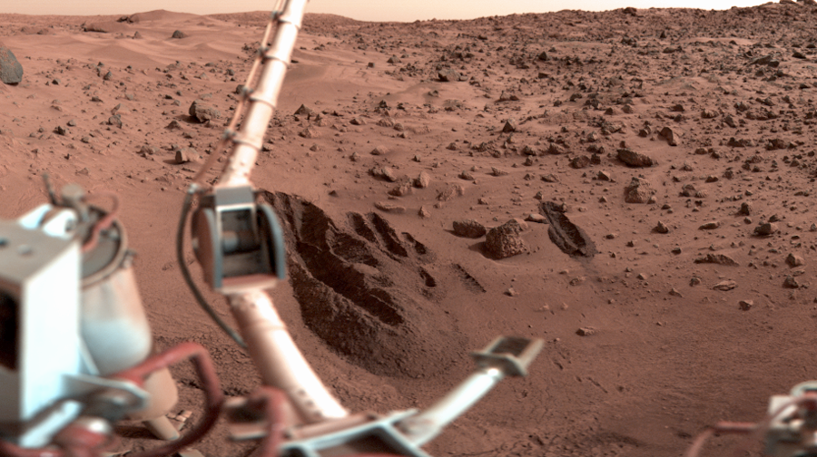
Испарение льда на дне канавки, сделанной аппаратом «Феникс» в 2008 г.
-

Испарение льда в свежих кратерах в серии изображений камеры HiRISE на аппарате Mars Reconnaissance Orbiter, 2009 г.
Запасы воды на Марсе в настоящее время[править | править код]
Лёд[править | править код]


Содержание льда в приповерхностном слое, измеренное аппаратом «Марс Одиссей» на низких широтах (слева) и в приполярных областях (справа).
В настоящее время открытые и достоверно установленные объёмы воды на Марсе сосредоточены преимущественно в так называемой криосфере — приповерхностном слое вечной мерзлоты мощностью в десятки и сотни метров. Бо́льшая часть этого льда находится под поверхностью планеты, поскольку при нынешних климатических условиях не может существовать стабильно и оказавшись на поверхности, быстро испаряется; только в приполярных областях температура достаточно низкая для стабильного существования льда в течение всего года — это полярные шапки. Общий объём льда на поверхности и в приповерхностном слое оценивается в 5 млн км³ (а в более глубоких слоях, вероятно, могут быть сосредоточены гораздо бо́льшие запасы подмерзлотных солёных вод. Их объём оценивается в 54-77 млн км³). В расплавленном состоянии он покрыл бы поверхность Марса слоем воды толщиной 35 м[34][35].
На полюсах концентрация водного льда в криосфере ожидаемо высока — до 100 %. Объём льда в полярных шапках планеты составляет 2-2,8 млн км³. На широтах выше 60° она практически везде не менее 20 %; ближе к экватору — в среднем несколько ниже, но всё же повсюду отлична от нуля, больше всего — до 10 % — в районе вулканов в Элизиуме, в Сабейской земле[en] и к северу от земли Сирен[en].
Жидкость[править | править код]
25 июля 2018 года вышел доклад об открытии, основанном на исследованиях радаром MARSIS. Работы показали наличие подлёдного озера на Марсе, расположенного на глубине 1,5 км подо льдом Южной полярной шапки, шириной около 20 км. Это стало первым известным постоянным водоёмом на Марсе.
Зондирование области шириной около 200 километров с помощью MARSIS показало, что поверхность Южного полюса Марса покрыта несколькими слоями льда и пыли и глубиной около 1,5 км. Особенно мощное усиление отражения сигнала было зафиксировано под слоистыми отложениями в пределах 20-километровой зоны на глубине около 1,5 км. Проанализировав свойства отраженного сигнала и изучив состав слоистых отложений, а также ожидаемый температурный профиль под поверхностью этой области, ученые пришли к выводу, что радар обнаружил под поверхностью карман с озером из жидкой воды. Прибор не смог определить, насколько глубоким может быть озеро, но его глубина должна составлять как минимум несколько десятков сантиметров (таким должен быть слой воды, чтобы его увидел MARSIS)[36][37]. Однако, повторный анализ радарных данных аппарата Mars Express и лабораторные эксперименты показали, что так называемые «озёра» могут являться гидратированными и холодными отложениями, включающими глину (смектиты), минералы, содержащие металлы, и солёный лёд[38].
Вода на Марсе в прошлом[править | править код]
Долгосрочные изменения климата[править | править код]
Водяной лёд не может стабильно существовать на Марсе при сегодняшних климатических условиях, однако подтверждено, что он присутствует в приповерхностном слое практически повсеместно, в том числе в приэкваториальных областях. Наиболее вероятно, что он оказался там в более ранний период эволюции планеты, когда угол наклона оси вращения Марса достигал больших значений порядка 45°. Численное моделирование показало, что при этом в полярных областях, которые становятся самыми тёплыми участками, H2O и CO2 сублимируются в атмосферу, затем вода конденсируется в лёд и снег в низких широтах, где теперь холодно, и таким образом полярные шапки смещаются к экватору[39]. Подтверждением этому являются обнаруживаемые во многих (в том числе приэкваториальных) областях Марса формы рельефа, напоминающие земные ледники: очевидно, что они сформировались именно в такой период[29]. Наоборот, когда наклон оси вращения уменьшается, в полярных областях снова становится холоднее, а в экваториальных — теплее; вода, замёрзшая там в приповерхностных слоях, сублимируется и снова конденсируется в ледяные полярные шапки[40]. Последовательное чередование этих периодов можно отследить по формирующимся таким образом слоистым отложениям в полярных шапках, однако для этого необходимо сделать допущение о том, сколько времени требуется на образование каждого слоя[41][42]. На предмет того, насколько частыми были такие смены, продолжается дискуссия: моделирование климата (ключевое влияние на который оказывает хаотический процесс изменения наклона угла оси вращения), особенно в геологических временных масштабах, на сегодняшний день невозможно с требуемой точностью[43][44].

Жидкая вода не может стабильно существовать на поверхности Марса при нынешних климатических условиях.
Вода (по крайней мере чистая) в жидком состоянии сейчас также не может существовать на Марсе стабильно, однако судя по многочисленным свидетельствам, ранее ситуация была иной. Очевидно, что для этого температура и парциальное давление водяного пара в атмосфере должны были быть выше тройной точки на фазовой диаграмме, тогда как сейчас они далеки от соответствующих значений. Если повысится только температура, а давление останется низким, лёд сублимируется напрямую в водяной пар, минуя жидкую фазу. Между тем, даже повысить температуру на 50° очень затруднительно и возможно лишь посредством парникового эффекта. Однако лавинный парниковый эффект за счёт паров воды в атмосфере, в отличие от Земли, на Марсе невозможен из-за низких температур, при которых водяной пар не сможет стабильно оставаться в атмосфере и неизбежно сконденсируется на поверхности планеты обратно в лёд. Но другой парниковый газ — CO2 — вполне может существовать в условиях Марса, и благодаря ему температура может повыситься до значений, при которых стабилен водяной пар, а когда его становится в атмосфере больше, его парциальное давление может стать достаточным уже для существования жидкой воды. Для этого необходимо парциальное давление углекислого газа порядка 1 атм[45]. Правда, если даже такой механизм имел место, неизвестно, куда делся теперь весь этот объём CO2, — он мог остаться в отложениях карбоната кальция либо улетучиться с остальной атмосферой[44].
Ряд авторов не разделяет эту гипотезу, полагая, что углекислый газ не может обеспечить достаточной интенсивности парникового эффекта[46][47]. Предлагались механизмы, задействующие другие парниковые газы, например, водород, предположительно вулканического происхождения[48]. На сегодняшний день на этот счёт нет общепринятой теории, во многом из-за трудностей моделирования парникового эффекта даже на Земле, в котором и по настоящий момент остаётся много неопределённости[49].
Эволюция гидросферы Марса[править | править код]

Расположение проточных палеоозёр, включая 30, атрибутированных по геологическим эпохам
Большой интерес в геологическом прошлом планеты Марс вызывают два периода — гесперийский и амазонийский[50].
Гесперийский период[править | править код]
Так мог бы выглядеть древний Марс, если бы на нём был океан.
В гесперийском периоде (3,5—2,5 млрд лет назад) Марс достиг вершины своей эволюции и имел постоянную гидросферу[51]. Северную равнину планеты в то время занимал солёный океан объёмом до 15-17 млн км³ и глубиной 0,7—1 км (для сравнения, Северный Ледовитый океан Земли имеет объём 18,07 млн км³). В отдельные промежутки времени этот океан распадался на два. Один океан, округлый, заполнял бассейн ударного происхождения в районе Утопии, другой, неправильной формы, — район Северного полюса Марса. В умеренных и низких широтах было много озёр и рек, на Южном плато — ледники. Марс обладал очень плотной атмосферой, аналогичной той, которая в то время была у Земли, при температуре у поверхности доходившей до 50 °C и давлении свыше 1 атмосферы. Теоретически в гесперийском периоде на Марсе могла существовать и биосфера.
Амазонийский период[править | править код]
В амазонийском периоде (около 2,5—1 млрд лет назад) климат на Марсе стал катастрофически быстро меняться. Происходили мощнейшие, но постепенно затухающие глобальные тектонические и вулканические процессы, в ходе которых возникли крупнейшие в Солнечной системе вулканы (Олимп), несколько раз сильно изменялись характеристики самой гидросферы и атмосферы, появлялся и исчезал Северный океан. Катастрофические наводнения, связанные с таянием криосферы привели к образованию грандиозных каньонов: в долину Ареса с южных нагорий Марса стекал поток полноводнее Амазонки; расход воды в долине Касей превышал 1 млрд м³/с. Миллиард лет назад активные процессы в литосфере, гидросфере и атмосфере Марса прекратились, и он принял современный облик. Виной глобальных катастрофических изменений марсианского климата считаются большой эксцентриситет орбиты и неустойчивость оси вращения, вызывающие огромные, до 45 %, колебания потока солнечной энергии, падающей на поверхность планеты; слабый приток тепла из недр Марса, обусловленный небольшой массой планеты, и высокой разрежённостью атмосферы, обусловленной высокой степенью её диссипации.
Примечания[править | править код]
- ↑ Spinrad, Hyron; Münch, Guido; Kaplan, Lewis D. Letter to the Editor: the Detection of Water Vapor on Mars : [англ.] : [арх. 21 октября 2022] // Astrophysical Journal. — 1963. — Т. 137 (May). — С. 1319—1319. — doi:10.1086/147613.
- ↑ Stoney, G. Johnstone. Of Atmospheres upon Planets and Satellites : [арх. 3 марта 2022] // Astrophysical Journal. — 1898. — Т. 7 (январь). — С. 25—55. — Bibcode: 1898ApJ…..7…25S. — doi:10.1086/140435.
- ↑ R.B. Leighton, B.C. Murray. Behavior of Carbon Dioxide and Other Volatiles on Mars : [англ.] : [арх. 3 марта 2022] // Science. — 1966. — Т. 153, № 3732 (8 July). — С. 136—144. — ISSN 0036-8075. — doi:10.1126/science.153.3732.136.
- ↑ PIA15090: Mariner 9 View of Nirgal Vallis (англ.). NASA (21 ноября 2011). Дата обращения: 24 июня 2017. Архивировано 13 сентября 2015 года.
- ↑ Daniel J. Milton. Water and processes of degradation in the Martian landscape : [англ.] // Journal of Geophysical Research. — 1973. — Т. 78, вып. 20 (10 July). — С. 4037—4047. — doi:10.1029/JB078i020p04037.
- ↑ Virginia C Gulick. Origin of the valley networks on Mars: a hydrological perspective : [англ.] : [арх. 1 мая 2017] // Geomorphology. — 2001. — Т. 37, вып. 3—4 (April). — С. 241—268. — doi:10.1016/S0169-555X(00)00086-6.
- ↑ ROBERT P. SHARP, MICHAEL C. MALIN. Channels on Mars : [англ.] // GSA Bulletin. — 1975. — Т. 86, № 5 (1 May). — С. 593—609. — doi:10.1130/0016-7606(1975)86<593:COM>2.0.CO;2.
- ↑ Michael H. Carr. The fluvial history of Mars : [англ.] : [арх. 6 августа 2017] // Philosophical Transactions of the Royal Society A. — 2012. — Т. 370 (2 April). — С. 2193—2215. — doi:10.1098/rsta.2011.0500.
- ↑ James W. Head III, Harald Hiesinger, Mikhail A. Ivanov, Mikhail A. Kreslavsky, Stephen Pratt, Bradley J. Thomson. Possible Ancient Oceans on Mars: Evidence from Mars Orbiter Laser Altimeter Data : [англ.] : [арх. 21 декабря 2016] // Science. — 1999. — Т. 286 (10 December). — С. 2134—2137. — doi:10.1126/science.286.5447.2134.
- ↑ J. Taylor Perron, Jerry X. Mitrovica, Michael Manga, Isamu Matsuyama & Mark A. Richards. Evidence for an ancient martian ocean in the topography of deformed shorelines : [англ.] // Nature. — 2007. — Т. 447 (14 July). — С. 840—843. — doi:10.1038/nature05873.
- ↑ Gaetano Di Achille & Brian M. Hynek. Ancient ocean on Mars supported by global distribution of deltas and valleys : [англ.] // Nature Geoscience. — 2010. — Т. 3 (June). — С. 459—463. — doi:10.1038/ngeo891.
- ↑ Michael C. Malin, Kenneth S. Edgett. Evidence for Recent Groundwater Seepage and Surface Runoff on Mars : [англ.] // Science. — 2000. — Т. 288, вып. 5475 (30 June). — С. 2330—2335. — doi:10.1126/science.288.5475.2330.
- ↑ Charles Q. Choi. Flashback: Water on Mars Announced 10 Years Ago (англ.). Space.com (22 июня 2010). Дата обращения: 16 июля 2017. Архивировано 23 ноября 2021 года.
- ↑ Kirby Runyon, Lujendra Ojha. Recurring Slope Lineae // Encyclopedia of Planetary Landforms. — Springer New York, 2014. — С. 1—6. — ISBN 978-1-4614-9213-9. Архивная копия от 6 августа 2017 на Wayback Machine
- ↑ Alfred S. McEwen, Lujendra Ojha, Colin M. Dundas, Sarah S. Mattson, Shane Byrne, James J. Wray, Selby C. Cull, Scott L. Murchie, Nicolas Thomas, Virginia C. Gulick. Seasonal Flows on Warm Martian Slopes : [англ.] // Science. — 2011. — Т. 333, вып. 6043 (5 August). — С. 740—743. — doi:10.1126/science.1204816.
- ↑ Lujendra Ojha, Mary Beth Wilhelm, Scott L. Murchie, Alfred S. McEwen, James J. Wray, Jennifer Hanley, Marion Massé and Matt Chojnacki. Spectral evidence for hydrated salts in recurring slope lineae on Mars : [англ.] // Nature Geoscience. — 2015. — Т. 8 (28 September). — С. 829—832. — doi:10.1038/NGEO2546.
- ↑ Ученые: полосы на Марсе остаются от потоков воды, BBC Русская служба (28 сентября 2015). Архивировано 30 января 2016 года. Дата обращения: 30 сентября 2015.
- ↑ Королёв, Владимир. На Марсе обнаружена жидкая соленая вода, N+1 (28 сентября 2015). Архивировано 29 сентября 2015 года. Дата обращения: 6 августа 2017.
- ↑ Сезонные потоки в долине Маринера, Новости астрономии и астрофизики — The Universe Times (24 мая 2017). Архивировано 7 августа 2017 года. Дата обращения: 6 августа 2017.
- ↑ David E.Stillman, Timothy I.Michaels, Robert E.Grimm. Characteristics of the numerous and widespread recurring slope lineae (RSL) in Valles Marineris, Mars : [англ.] // Icarus. — 2017. — Т. 285 (15 March). — С. 195—210. — doi:10.1016/j.icarus.2016.10.025.
- ↑ Christopher S. Edwards, Sylvain Piqueux. The water content of recurring slope lineae on Mars : [англ.] // Geophysical Research Letters. — 2016. — Т. 43, вып. 17 (14 September). — С. 8912—8919. — doi:10.1002/2016GL070179.
- ↑ W. V. Boynton, W. C. Feldman, S. W. Squyres, T. H. Prettyman, J. Brückner, L. G. Evans, R. C. Reedy, R. Starr, J. R. Arnold, D. M. Drake, P. A. J. Englert, A. E. Metzge, Igor Mitrofanov, J. I. Trombka, C. d’Uston, H. Wänke, O. Gasnault, D. K. Hamara, D. M. Janes, R. L. Marcialis, S. Maurice, I. Mikheeva, G. J. Taylor, R. Tokar, C. Shinohara. Distribution of Hydrogen in the Near Surface of Mars: Evidence for Subsurface Ice Deposits : [англ.] // Science. — 2002. — Т. 297, вып. 5578 (5 July). — С. 81—85. — doi:10.1126/science.1073722.
- ↑ Тунцов, Артём. Phoenix докопался до воды, Газета.ru (20 июня 2008). Архивировано 6 августа 2017 года. Дата обращения: 3 августа 2017.
- ↑ NASA Phoenix Mars Lander Confirms Frozen Water, Phoenix Mars Lander, NASA (6 августа 2020). Архивировано 19 мая 2017 года. Дата обращения: 3 августа 2017.
- ↑ New Impact Craters on Mars, Mars Reconnaissance Orbiter Mission, NASA (24 сентября 2009). Архивировано 17 января 2022 года. Дата обращения: 3 августа 2017.
- ↑ Shane Byrne et al. Distribution of Mid-Latitude GroundIce on Mars from New Impact Craters : [англ.] : [арх. 3 марта 2022] // Science. — 2009. — Т. 325, вып. 5948. — С. 1674. — doi:10.1126/science.1175307.
- ↑ David E. Shean, James W. Head, David R. Marchant. Origin and evolution of a cold-based tropical mountain glacier on Mars: The Pavonis Mons fan-shaped deposit : [англ.] // J. Geophys. Res.. — 2005. — Т. 110 (5 May). — С. E05001. — doi:10.1029/2004JE002360.
- ↑ 1 2 James L. Dickson, James W. Head, David R. Marchant. Late Amazonian glaciation at the dichotomy boundary on Mars: Evidence for glacial thickness maxima and multiple glacial phases : [англ.] // Geology. — 2008. — Т. 36, № 5 (May). — С. 411—414. — doi:10.1130/G24382A.1.
- ↑ 1 2 Head, J. W., et al. Tropical to mid-latitude snow and ice accumulation flow and glaciation on Mars : [арх. 12 августа 2017] // Nature. — 2005. — Т. 434 (17 марта). — С. 346—351. — doi:10.1038/nature03359.
- ↑ John W. Holt et al. Radar Sounding Evidence for Buried Glaciers in the Southern Mid-Latitudes of Mars : [англ.] // Science. — 2008. — Т. 322, вып. 5905 (21 November). — С. 1235—1238. — doi:10.1126/science.1164246.
- ↑ Архивированная копия. Дата обращения: 29 мая 2022. Архивировано 28 мая 2022 года.
- ↑ Zhao, J., Xiao, Z., Huang, J., Head, J. W., Wang, J., Shi, Y., et al. Geological Characteristics and Targets of High Scientific Interest in the Zhurong Landing Region on Mars (англ.) // Geophysical Research Letters. — 2021. — Vol. 48, no. 20. — P. e2021GL094903.
- ↑ A winter wonderland in red and white – Korolev Crater on Mars (англ.). German Aerospace Center (DLR) (20 декабря 2018). Дата обращения: 18 мая 2019. Архивировано 17 октября 2020 года.
- ↑ Ice (англ.). Mars Education at Arizona State University. NASA. Дата обращения: 7 августа 2017. Архивировано 12 августа 2017 года.
- ↑ Кузьмин Р. О., Галкин И. Н. Криолитосфера Марса и ее строение // Как устроен Марс. — Москва: Знание, 1989. — Т. 8. — 64 с. — (Космонавтика, астрономия). — 26 953 экз. — ISBN 5-07000280-5. Архивная копия от 29 января 2018 на Wayback Machine
- ↑ Halton, Mary. Liquid water ‘lake’ revealed on Mars (англ.), BBC News (25 July 2018). Архивировано 25 июля 2018 года. Дата обращения: 28 июля 2018.
- ↑ Ashley Strickland. Evidence detected of lake beneath Mars’ surface, CNN (25 июля 2018). Архивировано 27 июля 2018 года. Дата обращения: 28 июля 2018.
- ↑ Clays, Not Water, Are Likely Source of Mars ‘Lakes’ Архивная копия от 7 августа 2021 на Wayback Machine, July 29, 2021
- ↑ F. Forget, R. M. Haberle, F. Montmessin, B. Levrard, J. W. Head. Formation of Glaciers on Mars by Atmospheric Precipitation at High Obliquity : [англ.] // Science. — 2006. — Т. 311, вып. 5759 (20 January). — С. 368—371. — doi:10.1126/science.1120335.
- ↑ Benjamin Levrard, François Forget, Franck Montmessin & Jacques Laskar. Recent ice-rich deposits formed at high latitudes on Mars by sublimation of unstable equatorial ice during low obliquity : [англ.] // Nature. — 2004. — Т. 431 (28 November). — С. 1072—1075. — doi:10.1038/nature03055.
- ↑ Laskar, Jacques; Levrard, Benjamin; Mustard, John F. Orbital forcing of the martian polar layered deposits : [англ.] : [арх. 13 августа 2017] // Nature. — 2002. — Т. 419, № 6905 (26 September). — С. 375—377. — doi:10.1038/nature01066.
- ↑ Levrard, B., F. Forget, F. Montmessin, and J. Laskar. Recent formation and evolution of northern Martian polar layered deposits as inferred from a Global Climate Model : [англ.] : [арх. 13 августа 2017] // J. Geophys. Res.. — 2007. — Т. 112, вып. E6 (28 June). — С. E06012. — doi:10.1029/2006JE002772.
- ↑ Edwin S. Kite, Michael Andrew Mischna, Mohit Melwani Daswani. Quantifying the effect of Mars obliquity on the intermittency of post-Noachian surface liquid water (англ.) (2014). Дата обращения: 12 августа 2017. Архивировано 12 сентября 2015 года.
- ↑ 1 2 N. Mangold, D. Baratoux, O. Witasse, T. Encrenaz, C. Sotin. Mars: a small terrestrial planet : [англ.] : [арх. 31 июля 2017] // The Astronomy and Astrophysics Review. — 2016. — Т. 24, № 1 (16 December). — С. 15. — doi:10.1007/s00159-016-0099-5.
- ↑ J.B.Pollack, J.F.Kasting. The case for a wet, warm climate on early Mars : [англ.] // Icarus. — Т. 71, вып. 2. — С. 203—224. — doi:10.1016/0019-1035(87)90147-3.
- ↑ R. Wordsworth, F. Forget, E. Millour, J.W. Head, J.-B. Madeleine, B. Charnay. Global modelling of the early martian climate under a denser CO2 atmosphere: Water cycle and ice evolution : [англ.] : [арх. 13 августа 2017] // Icarus. — 2013. — Т. 222, вып. 1 (January). — С. 1—19. — doi:10.1016/j.icarus.2012.09.036.
- ↑ Chevrier, Vincent; Poulet, Francois; Bibring, Jean-Pierre. Early geochemical environment of Mars as determined from thermodynamics of phyllosilicates : [англ.] : [арх. 13 августа 2017] // Nature. — 2007. — Т. 448 (5 July). — С. 60—63. — doi:10.1038/nature0596160.
- ↑ Ramses M. Ramirez. A warmer and wetter solution for early Mars and the challenges with transient warming : [англ.] // Icarus. — 2017. — Т. 297 (15 November). — С. 71—82. — doi:10.1016/j.icarus.2017.06.025.
- ↑ Greicius, Tony. NASA’s Curiosity Rover Sharpens Paradox of Ancient Mars, NASA (6 февраля 2017). Архивировано 9 февраля 2017 года. Дата обращения: 29 июля 2017.
- ↑ Determining the age of surfaces on Mars. Дата обращения: 17 ноября 2007. Архивировано 19 февраля 2007 года.
- ↑ The Case of the Missing Mars Water. Дата обращения: 17 ноября 2007. Архивировано из оригинала 26 марта 2010 года.
Ссылки[править | править код]
- Водные потоки и бассейны на Марсе // Elementy.ru
- Солёная вода на Марсе // galspace.spb.ru
- Анализ метеорита показал: Марс был влажным с самого рождения // Вести — Наука, 3 ноября 2020
- «Удивительный Марс» — лекция Сурдина В. Г. в Московском планетарии, 23.01.2013 (видео на YouTube)
- НАСА обнаружило жидкую воду на Марсе (видео на YouTube)
Мистерия марсианской воды
Время на прочтение
5 мин
Количество просмотров 26K

Вода на Марсе. Сколько копий сломано в спорах на эту тему, сколько книг и статей написано, научных и не очень. Сколько карикатур и демотиваторов нарисовано… Воду на Марсе нашли. Потом еще раз нашли. Потом еще раз… И еще… Даже за 2015 год нашли уже два раза, но все равно, каждый новый раз в СМИ подается как сенсация. Давайте уже разберемся с этой темой.
В процессе изучения Марса, с момента изобретения телескопа, и до сегодняшнего времени, представления о марсианской воде менялись от “вижу моря и океаны”, до “нет ни капли воды”, и потом снова к “вижу океан”.
Примерно вот так могли видеть Марс люди позапрошлого века в самые мощные телескопы:
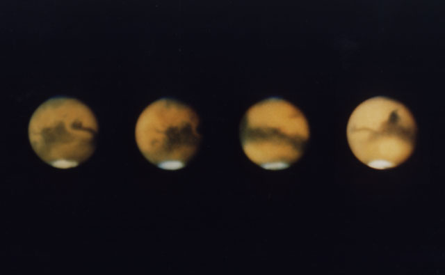
Белые полярные шапки наводили на мысли о сходстве полюсов Марса и Земли. А темные пятна казались кому-то океанами, а кому-то джунглями. В общем, мирок представлялся довольно похожим на наш, не удивительно, что марсиане плотно прописались в земной художественной культуре на полтора века.
К середине ХХ века методики телескопических наблюдений немного улучшились, к наблюдениям добавилась фотография. Все меньше ученых видело на Марсе каналы, и все больше Красная планета представлялась вымирающей или безжизненной пустыней. Грубые попытки подсчета температуры поверхности давали минусовые показатели вплоть до -100 градусов по Цельсию, но им тогда не хотели верить.
Жирную точку на марсианских морях и лесах поставил космический аппарат Mariner-4, а следом за ним Mariner-9 и “Марс-5”.
Стало ясно, что на Марсе нет ни рукотворных каналов, ни следов растительности, ни крупных водоемов. Даже полярные шапки оказались покрыты углекислотным льдом.
Зато нашлись пересохшие речные русла. Находка давала надежды, что вода была хотя бы в прошлом, но порождала вопросы о том где она сейчас. Впрочем, пустынность Марса не помешала сформировать вполне современные и достоверные гипотезы о том, что сезонные изменения полярных шапок зависят от намерзания и испарения углекислоты, а вот летние остатки, которые не меняются год от года на полюсах — это водяной лед.
Об этом написано еще в Большой Советской энциклопедии в 1968 году.
Первые исследования марсианского грунта с поверхности дали отрицательные результаты. Спускаемые аппараты программы NASA Viking в 70-х гг. сели в средних широтах северного полушария Марса, и должны были не только определить наличие микроорганизмов в грунте, но и узнать есть ли в нем вода. Полученные результаты оказались не обнадеживающими, газовый хроматограф аппаратов определил всего 1% влаги.
Следующий этап поиска проходил уже в 90-е. С орбиты спутник Mars Global Surveyor наснимал еще больше свидетельств водного прошлого Марса. Например, классическую речную дельту в кратере Эберсвальде.
Когда-то в кратере было озеро, в которое впадала река. Частички грунта, влекомые течением оседали в озере формируя многослойные отложения. Этот кратер и дельту рассматривают в качестве одного из будущих возможных целей для исследования марсоходами.
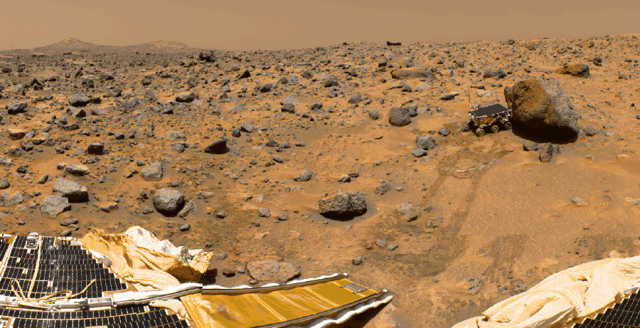
В 1997-м году на Марсе сел спускаемый модуль Mars Pathfinder с родоначальником всех марсоходов NASA — Sojourner. Его отправили в местность, которая из космоса выглядела как широкое русло огромной реки, вроде пересохшей Амазонки.
К сожалению многих, на поверхности практически ничего не указывало на воздействие воды. Равнина оказалась усыпана вулканическими валунами и песком. Sojourner смог определить у некоторых камней следы воздействия воды, но совсем уж незначительные.
После первых неудач на марсианскую воду начали полномасштабную охоту. На орбиту запустили спутники NASA Mars Odyssey в 2001 году, и ESA Mars Express. На обоих аппаратах были размещены различные исследовательские средства поиска воды, в том числе и российского производства.
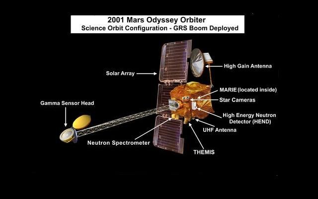
Mars Odyssey оборудовали гамма детектором GRS и детектором нейтронов (HEND от Института космических исследований РАН). Они ловили космическое гамма излучение и нейтроны, отраженные от поверхности Марса. Атомы водорода, содержащиеся в приповерхностных слоях грунта, задерживают нейтроны и испускают гамма-фотоны под ударами космических частиц, что позволяет определять примерное содержание водорода. Поскольку газ там не задержится, то водород может быть только в связанном виде, чаще всего в молекулах воды.
Два прибора позволили составить первые карты предполагаемого распределения воды в грунте Марса.
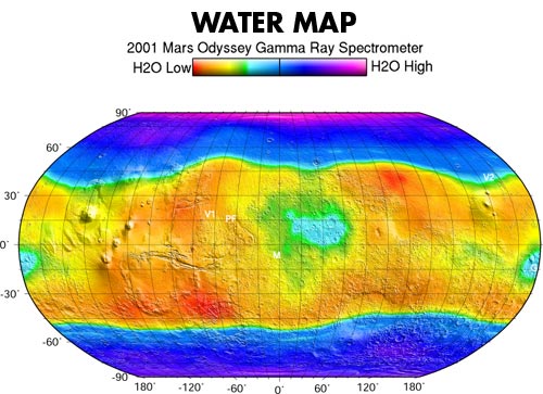
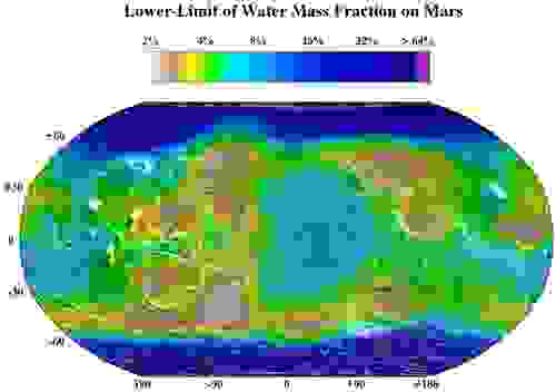
Оказалось не все так плохо. Вода все-таки есть. Приборы подтверждали друг друга, но воду хотелось увидеть непосредственно, “пощупать” и проанализировать.
Отличить водяной лед от углекислотного на полюсах удалось прибору OMEGA, на спутнике Mars Express. Этот спектрометр смог увидеть поверхностный слой (розовый на снимке) замерзшего СО2, и голубой лед Н2О (синий) в глубоких расщелинах.
К 2005 году Mars Express развернул антенны радара MARSIS, который смог “просвечивать” кору Марса до глубины в несколько километров. Этот радар смог сделать “УЗИ” марсианских полярных шапок и получить их профили “в разрезе”.
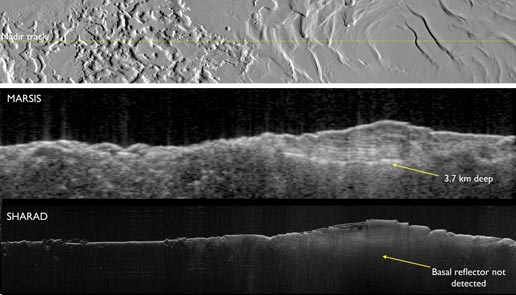
Благодаря этому исследованию удалось определить, что водяной лед на северной полярной шапке отложился толщиной до 1,7 км, а южной — до 4 км. Углекислотный же лед оказался толщиной всего в несколько метров — до 8 на Южном полюсе. Более того, радар получил данные в нескольких участках, где отражение радиоволн можно интерпретировать, как отражение от жидкого водоема. Т.е. есть остается некоторая надежда найти на Марсе аналог земного подледного антарктического озера Восток. И если кто-то еще надеется найти марсианскую жизнь — это самое подходящее место. Впрочем, пока нет однозначной уверенности, что кто-то обитает и в земном Востоке, поэтому не известно мог ли кто-нибудь выжить в вероятном марсианском.
Тем временем, в 2004 году на Марсе высадилась пара марсоходов: Spirit и Opportunity. Их отправляли туда, где ожидали найти и исследовать участки местности, пережившие значительное воздействие воды.
Opportunity высадили на равнину Меридиана туда, где наблюдалась высокая концентрация гематита. Эта форма железной руды образуется под воздействием грунтовых вод или на дне мелководных озер.
Spirit направили в кратер Гусева, где ожидали найти следы реки, озера или даже морского залива.
По иронии судьбы, Opportunity осуществил практически все первоначальные цели, едва только ступил на поверхность Марса. Он нашел гематит, нашел слоистые отложения, нашел отпечатки кристаллов соли, которые оставались при пересыхании водоема. С поверхности он смог подтвердить то, что и так было понятно — на Марсе когда-то была вода, причем физические условия позволяли оставаться ей жидкой. Т.е. когда-то Марс был теплее, и имел более плотную атмосферу.

Впоследствии ученым пришлось погонять Opportunity по равнине, чтобы найти ему новую подходящую цель для исследования. Такой целью стала глина, которая могла откладываться только в пресной воде. Ранее марсоходу попадались только признаки соленых и кислотных водоемов не очень пригодных к жизни в них.
Глину он тоже нашел. Преодолел марафонскую дистанцию в 42 км и на днях разменял четырехтысячный марсианский день. Работа продолжается.
Spirit прожил короткую, но бурную жизнь. Сначала не нашел никаких признаков деятельности воды на поверхности. Затем, через 5 километров, и благодаря сломанной “ноге” нашел признаки некогда существовавших древних гейзеров. В конце своей карьеры Spirit нашел еще признак пересохшего водоема — кучу соли в яме. Эта соль и стала его могилой.
Продолжение.
В следующей серии вы узнаете много ли воды осталось на Марсе, где ее искать кроме полюсов, и откуда берутся весенние ручьи.
Российский ученый раскрыл истинную значимость находки следов воды на Марсе
Вода на Красной планете могла плескаться еще каких-то 400 тысяч лет назад: китайцы изменили представление о времени ее исчезновения
Вода на Марсе могла существовать в те времена, когда мы – представители рода Homo sapiens – уже ходили по Земле. Китайские ученые из Института геологии и геофизики Китайской академии наук по данным, полученным с марсохода «Чжужун» (Zhurong), определили, что глубинные океаны могли плескаться на соседней планете в промежутке от 1,4 миллиона до 400 тысяч лет назад.
Напомним, что «Чжужун» совершил мягкую посадку на равнине Утопия 14 мая 2021 года. К 7 мая 2022 года он проработал 349 солов (1 сол равен продолжительности средних солнечных суток на Марсе, или же «сола», то есть составляет 24 часа 39 минут и 35,244 секунды). За это время марсоход прошел около 2 тысяч километров и передал на Землю 940 Гб разнообразных научных данных. Затем, в преддверии наступающей на Марсе зимы, он перешел в спящий режим. Предполагалось, что после зимовки «Чжужун» возобновит работу в декабре 2022 года, однако аппарат из спящего режима пока не вышел.
Результаты, опубликованные китайскими исследователями, опираются на ранее полученные данные, когда марсоход еще исследовал равнину Утопия.
Справка «МК»: равнина Утопия – округлая низменность диаметром около 3300 км в восточной части северного полушария Марса. Равнина представляет собой бывший ударный кратер, образовавшийся в результате падения астероида.
«Чжужун» исследовал рисунок ее дюн и «передал» исследователям фотографии их тонких потрескавшихся корок. На них также присутствовали скопления частиц, очень напоминающих соляной осадок, оставшийся после испарения жидкой воды. Анализ дюн Утопии показал, что вода могла присутствовать на планете между 1,4 миллионами и 400 тысячами лет назад.
Комментарий кандидата физико-математических наук, руководителя Лаборатории прикладной инфракрасной спектроскопии МФТИ Александра Родина:
– Самое интересное в этой работе, конечно, – возраст следов воды: между 1,4 миллиона и 400 тысячами лет назад. Раньше считалось, что жидкая вода на Марсе могла быть лишь миллиарды лет назад.
– И что она собой представляла, скажем, 400-500 тысяч лет назад, когда на Земле уже наступил каменный век?
– Замечу, что это был не океан, не реки: мы знаем, что при марсианском низком атмосферном давлении никакой устойчивой жидкой воды в те времена на Марсе быть не могло. Это был рассол, причем сильно концентрированный раствор солей, кислот и прочих, малопригодных для жизни компонентов, который как-то просачивался из недр Марса на поверхность и сразу испарялся. От той воды остались лишь разводы соли, как на обуви зимой. Естественно, что жить в ней никто не мог.
Самая же главная интрига заключается в том, что китайцы обнаружили следы соленой воды в экваториальных областях, где наличия воды никто особенно не ожидал (водяной лед концентрируется в основном на полюсах). Однако мы знаем, что когда меняется угол наклона оси вращения Марса (это происходит с разными периодами), климат существенно меняется, и вода накапливается как раз в районе экватора, в так называемых низких широтах.
– Эта вода теоретически сейчас может сегодня находиться под поверхностью Марса?
– Мы точно знаем, что в высоких широтах она есть, и ее много! В низких широтах вся имеющаяся вода может быть связана в виде гидратов (продуктов присоединения воды к неорганическим и органическим веществам. – Авт.).
To date, interplanetary spacecraft have provided abundant evidence of water on Mars, dating back to the Mariner 9 mission, which arrived at Mars in 1971. This article provides a mission by mission breakdown of the discoveries they have made. For a more comprehensive description of evidence for water on Mars today, and the history of water on that planet, see Water on Mars.
Mariner 9[edit]
Mariner 9 imaging revealed the first direct evidence of water in the form of river beds, canyons (including the Valles Marineris, a system of canyons over about 4,020 kilometres (2,500 mi) long), evidence of water erosion and deposition, weather fronts, fogs, and more.[1] The findings from the Mariner 9 missions underpinned the later Viking program. The enormous Valles Marineris canyon system is named after Mariner 9 in honor of its achievements.
-

Warrego Valles, as seen by Mariner 9. This image suggests that rain/snow was necessary to form this kind of branched network of channels.
Viking program[edit]
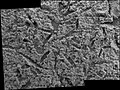
By discovering many geological forms that are typically formed from large amounts of water, Viking orbiters caused a revolution in our ideas about water on Mars. Huge river valleys were found in many areas. They showed that floods of water broke through dams, carved deep valleys, eroded grooves into bedrock, and traveled thousands of kilometers.[2] Large areas in the southern hemisphere contained branched valley networks, suggesting that rain once fell. The flanks of some volcanoes are believed to have been exposed to rainfall because they resemble those occurring on Hawaiian volcanoes.[3] Many craters look as if the impactor fell into mud. When they were formed, ice in the soil may have melted, turned the ground into mud, then the mud flowed across the surface.[4] Normally, material from an impact goes up, then down. It does not flow across the surface, going around obstacles, as it does on some Martian craters.[5][6][7] Regions, called “chaotic terrain”, seemed to have quickly lost great volumes of water which caused large channels to form downstream. The amount of water involved was almost unthinkable—estimates for some channel flows run to ten thousand times the flow of the Mississippi River.[8] Underground volcanism may have melted frozen ice; the water then flowed away and the ground just collapsed to leave chaotic terrain.
The images below, some of the best from the Viking Orbiters, are mosaics of many small, high resolution images. Click on the images for more detail. Some of the pictures are labeled with place names.
-

Streamlined Islands seen by Viking showed that large floods occurred on Mars. Image is located in Lunae Palus quadrangle.
-
Tear-drop shaped islands caused by flood waters from Maja Valles, as seen by Viking Orbiter. Image is located in Oxia Palus quadrangle. The islands are formed in the ejecta of Lod, Bok, and Gold craters.
-

Scour Patterns, located in Lunae Palus quadrangle, were produced by flowing water from Maja Valles, which lies just to the left of this mosaic. Detail of flow around Dromore crater is shown on the next image.
-

Great amounts of water were required to carry out the erosion shown in this Viking image. Image is located in Lunae Palus quadrangle. The erosion shaped the ejecta around Dromore crater.
-

The ejecta from Arandas crater acts like mud. It moves around small craters (indicated by arrows), instead of just falling down on them. Craters like this suggest that large amounts of frozen water were melted when the impact crater was produced. Image is located in Mare Acidalium quadrangle and was taken by Viking Orbiter.
-

This view of the flank of Alba Mons shows several channels/troughs. Some channels are associated with lava flows; others are probably caused by running water. A large trough or graben turns into a line of collapse pits. Image is located in Arcadia quadrangle and was taken by Viking Orbiter.
-

Branched channels in Thaumasia quadrangle, as seen by Viking Orbiter. Networks of channels like this are strong evidence for rain on Mars in the past.
-

The branched channels seen by Viking from orbit strongly suggested that it rained on Mars in the past. Image is located in Margaritifer Sinus quadrangle.
Results from Viking lander experiments strongly suggest the presence of water in the present and in the past of Mars. All samples heated in the gas chromatograph-mass spectrometer (GSMS) gave off water. However, the way the samples were handled prohibited an exact measurement of the amount of water. But, it was around 1%.[9] General chemical analysis suggested the surface had been exposed to water in the past. Some chemicals in the soil contained sulfur and chlorine that were like those remaining after sea water evaporates. Sulfur was more concentrated in the crust on top of the soil, than in the bulk soil beneath. So it was concluded that the upper crust was cemented together with sulfates that were transported to the surface dissolved in water. This process is common on Earth’s deserts. The sulfur may be present as sulfates of sodium, magnesium, calcium, or iron. A sulfide of iron is also possible.[10] Using results from the chemical measurements, mineral models suggest that the soil could be a mixture of about 90% iron-rich clay, about 10% magnesium sulfate (kieserite?), about 5% carbonate (calcite), and about 5% iron oxides (hematite, magnetite, goethite?). These minerals are typical weathering products of mafic igneous rocks. The presence of clay, magnesium sulfate, kieserite, calcite, hematite, and goethite strongly suggest that water was once in the area.[11] Sulfate contains chemically bound water, hence its presence suggests water was around in the past. Viking 2 found similar group of minerals. Because Viking 2 was much farther north, pictures it took in the winter showed frost.
-

Frost on Mars.
-

Frost at the landing site.
Mars Global Surveyor[edit]

Map showing distribution of hematite in Sinus Meridiani, as seen by TES. This data was used to target the landing of Opportunity Rover. Hematite is usually formed in the presence of water. Opportunity landed here and found definite evidence for water.
The Mars Global Surveyor’s Thermal Emission Spectrometer (TES) is an instrument able to detect mineral composition on Mars. Mineral composition gives information on the presence or absence of water in ancient times. TES identified a large (30,000 square-kilometer) area (in the Nili Fossae formation) that contained the mineral olivine. It is thought that the ancient impact that created the Isidis basin resulted in faults that exposed the olivine. Olivine is present in many mafic volcanic rocks; in the presence of water it weathers into minerals such as goethite, chlorite, smectite, maghemite, and hematite. The discovery of olivine is strong evidence that parts of Mars have been extremely dry for a long time. Olivine was also discovered in many other small outcrops within 60 degrees north and south of the equator.[12] Olivine has been found in the SNC (shergottite, nakhlite, and chassigny) meteorites that are generally accepted to have come from Mars.[13] Later studies have found that olivine-rich rocks cover more than 113,000 square kilometers of the Martian surface. That is 11 times larger than the five volcanoes on the Big Island of Hawaii.[14]
On December 6, 2006 NASA released photos of two craters called Terra Sirenum and Centauri Montes which appear to show the presence of liquid water on Mars at some point between 1999 and 2001.[15][16]
Hundreds of gullies have been discovered that were formed from liquid water, possible in recent times. These gullies occur on steep slopes and mostly in certain bands of latitude.[17][18][19][20][21]
Below are some examples of gullies that were photographed by Mars Global Surveyor.
-

Group of gullies on north wall of crater that lies west of the crater Newton (41.3047 degrees south latitude, 192.89 east longitide). Image is located in the Phaethontis quadrangle.
-

Gullies in a crater in Eridania quadrangle, north of the large crater Kepler. Features that may be remains of old glaciers are present. One, to the right, has the shape of a tongue.
-

Gullies on one wall of Kaiser crater. Gullies usually are found in only one wall of a crater. Location is Noachis quadrangle.
A few channels on Mars displayed inner channels that suggest sustained fluid flows. The best-known is the one in Nanedi Valles. Another was found in Nirgal Vallis.[17]

Inner channel (near top of the image) on floor of Nanedi Valles that suggests that water flowed for a fairly long period. Image from Lunae Palus quadrangle.
Many places on Mars show dark streaks on steep slopes, such as crater walls. Dark slope streaks have been studied since the Mariner and Viking missions.[22] It seems that streaks start out being dark, then they become lighter with age. Often they originate with a small narrow spot, then widen and extend downhill for hundreds of meters. Streaks do not seem to be associated with any particular layer of material because they do not always start at a common level along a slope. Although many of the streaks appear very dark, they are only 10% or less darker than the surrounding surface. Mars Global Surveyor found that new streaks have formed in less than one year on Mars.
Several ideas have been advanced to explain the streaks. Some involve water,[23] or even the growth of organisms.[24][25] The generally accepted explanation for the streaks is that they are formed from the avalanching of a thin layer of bright dust that is covering a darker surface. Bright dust settles on all Martian surfaces after a period of time.[17]
Dark streaks can be seen in the images below, as seen from Mars Global Surveyor.
-

Layers in Tikhonravov crater in Arabia. Layers may form from volcanoes, the wind, or by deposition under water. The craters on the left are pedestal craters. Dark slope streaks are seen to originate from certain layers (you may need to click on image to see the streaks).
-

Tikhonravov crater floor in Arabia quadrangle. Click on image to see dark slope streaks and layers.
-
Some parts of Mars show inverted relief. This occurs when materials are deposited on the floor of a stream then become resistant to erosion, perhaps by cementation. Later the area may be buried. Eventually erosion removes the covering layer. The former streams become visible since they are resistant to erosion. Mars Global Surveyor found several examples of this process.[26] Many inverted streams have been discovered in various regions of mars, especially in the Medusae Fossae Formation,[27] Miyamoto Crater,[28] and the Juventae Plateau.[29][30]
The image below shows one example.
Mars Pathfinder[edit]
Pathfinder found temperatures varied on a diurnal cycle. It was coldest just before sunrise (about −78 Celsius) and warmest just after Mars noon (about −8 Celsius). These extremes occurred near the ground which both warmed up and cooled down fastest. At this location, the highest temperature never reached the freezing point of water (0 °C), so Mars Pathfinder confirmed that where it landed it is too cold for liquid water to exist. However, water could exist as a liquid if it were mixed with various salts.[31]
Surface pressures varied diurnally over a 0.2 millibar range, but showed 2 daily minima and two daily maxima. The average daily pressure decreased from about 6.75 millibars to a low of just under 6.7 millibars, corresponding to when the maximum amount of carbon dioxide had condensed on the south pole. The pressure on the Earth is generally close to 1000 millibars, so the pressure on Mars is very low. The pressures measured by Pathfinder would not permit water or ice to exist on the surface. But, if ice were insulated with a layer of soil, it could last a long time.[32]
Other observations were consistent with water being present in the past. Some of the rocks at the Mars Pathfinder site leaned against each other in a manner geologists term imbricated. It is believed strong flood waters in the past pushed the rocks around until they faced away from the flow. Some pebbles were rounded, perhaps from being tumbled in a stream. Parts of the ground are crusty, maybe due to cementing by a fluid containing minerals.[33]
There was evidence of clouds and maybe fog.[33]
Mars Odyssey[edit]
In July 2003, at a conference in California, it was announced that the Gamma Ray Spectrometer (GRS) on board the Mars Odyssey had discovered huge amounts of water over vast areas of Mars. Mars has enough ice just beneath the surface to fill Lake Michigan twice.[34] In both hemispheres, from 55 degrees latitude to the poles, Mars has a high density of ice just under the surface; one kilogram of soil contains about 500 g of water ice. But, close to the equator, there is only 2 to 10% of water in the soil.[35][36] Scientists believe that much of this water is locked up in the chemical structure of minerals, such as clay and sulfates. Previous studies with infrared spectroscopes have provided evidence of small amounts of chemically or physically bound water.[37][38] The Viking landers detected low levels of chemically bound water in the Martian soil.[9] It is believed that although the upper surface only contains a percent or so of water, ice may lie just a few feet deeper. Some areas, Arabia Terra, Amazonis quadrangle, and Elysium quadrangle contain large amounts of water.[35][39] Analysis of the data suggest that the southern hemisphere may have a layered structure.[40] Both of the poles showed buried ice, but the north pole had none close to it because it was covered over by seasonal carbon dioxide (dry ice). When the measurements were gathered, it was winter at the north pole so carbon dioxide had frozen on top of the water ice.[34] There may be much more water further below the surface; the instruments aboard the Mars Odyssey are only able to study the top meter or so of soil. If all holes in the soil were filled by water, this would correspond to a global layer of water 0.5 to 1.5 km deep.[41]
The Phoenix lander confirmed the initial findings of the Mars Odyssey.[42] It found ice a few inches below the surface and the ice is at least 8 inches deep. When the ice is exposed to the Martian atmosphere it slowly sublimates. In fact, some of the ice was exposed by the landing rockets of the craft.[43]

View underneath Phoenix lander towards south foot pad, showing patchy exposures of a bright surface that was later proven to be water ice, as predicted by theory and detected by Mars Odyssey.
Thousands of images returned from Odyssey support the idea that Mars once had great amounts of water flowing across its surface. Some pictures show patterns of branching valleys. Others show layers that may have formed under lakes. Deltas have been identified.[44]
For many years researchers believed that glaciers existed under a layer of insulating rocks.[45][46][47][48][49] Lineated deposits are one example of these probable rock-covered glaciers. They are found on the floors of some channels. Their surfaces have ridged and grooved materials that deflect around obstacles. Some glaciers on the Earth show such features. Lineated floor deposits may be related to lobate debris aprons, which have been proven to contain large amounts of ice by orbiting radar.[48][49][50]
The pictures below, taken with the THEMIS instrument on board the Mars Odyssey, show examples of features that are associated with water present in the present or past.[51]
-

Reull Vallis with lineated floor deposits. Click on image to see relationship to other features. Floor deposits are believed to be formed from ice movement. Location is Hellas quadrangle.
-

Auqakuh Vallis. At one time a dark layer covered the whole area, now only a few pieces remain as buttes. Click on image to see layers. Layers may have formed from deposition on the bottom of lakes.
-

Nirgal Vallis that runs in two quadrangles has features looking like those caused by sapping. Nirgal Vallis is one of many ancient river valleys studied by THEMIS.
-

Nirgal Vallis.
-

Nirgal Vallis close-up.
-

Channels near Warrego Valles. These branched channels are strong evidence for flowing water on Mars, perhaps during a much warmer period.
-
Erosion features in Ares Vallis – the streamlined shape was probably formed by running water.
-

-
-

-
-
-

Channels west of Echus Chasma. The fine pattern of branching valleys were probably formed by water moving across the surface. Image is in Coprates quadrangle.
Much of the surface of Mars is covered by a thick smooth mantle that is thought to be a mixture of ice and dust.[52][53] This ice-rich mantle, a few yards thick, smooths the land, but in places it displays a bumpy texture, resembling the surface of a basketball. The low density of craters on the mantle means it is relatively young.
Changes in Mars’s orbit and tilt cause significant changes in the distribution of water ice. During certain climate periods water vapor leaves polar ice and enters the atmosphere. The water returns to the ground at lower latitudes as deposits of frost or snow mixed generously with dust. The atmosphere of Mars contains a great deal of fine dust particles. Water vapor condenses on the particles, then they fall down to the ground due to the additional weight of the water coating. When ice at the top of the mantling layer returns to the atmosphere, it leaves behind dust, which insulates the remaining ice.[54]

Dao Vallis begins near a large volcano, called Hadriaca Patera, so it is thought to have received water when hot magma melted huge amounts of ice in the frozen ground. The partially circular depressions on the left side of the channel in the image above suggests that groundwater sapping also contributed water.[55]
In some areas large river valleys begin with a landscape feature called “chaos” or chaotic terrain.” It is thought that the ground collapsed, as huge amounts of water were suddenly released. Examples of chaotic terrain, as imaged by THEMIS, are shown below.
-

Blocks in Aram Chaos showing possible source of water. The ground collapsed when large amounts of water were released. The large blocks probably still contain some water ice. Location is Oxia Palus quadrangle.
Phoenix[edit]
The Phoenix lander confirmed the existence of large amounts of water ice in the northern regions of Mars.[42] This finding was predicted by theory.[56]
and was measured from orbit by the Mars Odyssey instruments.[36]
On June 19, 2008, NASA announced that dice-sized clumps of bright material in the “Dodo-Goldilocks” trench, dug by the robotic arm, had vaporized over the course of four days, strongly implying that the bright clumps were composed of water ice which sublimated following exposure. Even though dry ice also sublimates under the conditions present, it would do so at a rate much faster than observed.[57][58][59]
On July 31, 2008, NASA announced that Phoenix confirmed the presence of water ice on Mars. During the initial heating cycle of a new sample, the Thermal and Evolved-Gas Analyzer’s (TEGA) mass spectrometer detected water vapor when the sample temperature reached 0 °C.[60]
Liquid water cannot exist on the surface of Mars with its present low atmospheric pressure, except at the lowest elevations for short periods.[61][62]
Results published in the journal Science after the mission ended reported that chloride, bicarbonate, magnesium, sodium potassium, calcium, and possibly sulfate were detected in the samples. Perchlorate (ClO4), a strong oxidizer, was confirmed to be in the soil. The chemical when mixed with water can greatly lower freezing points, in a manner similar to how salt is applied to roads to melt ice. Perchlorate may be allowing small amounts of liquid water to form on Mars today. Gullies, which are common in certain areas of Mars, may have formed from perchlorate melting ice and causing water to erode soil on steep slopes.[63]
Additionally, during 2008 and early 2009, a debate emerged within NASA over the presence of ‘blobs’ which appeared on photos of the vehicle’s landing struts, which have been variously described as being either water droplets or ‘clumps of frost’.[64] Due to the lack of consensus within the Phoenix science project, the issue had not been raised in any NASA news conferences.[64] One scientist’s view poised that the lander’s thrusters splashed a pocket of brine from just below the Martian surface onto the landing strut during the vehicle’s landing. The salts would then have absorbed water vapor from the air, which would have explained how they appeared to grow in size during the first 44 Martian days before slowly evaporating as Mars temperature dropped.[64][65] Some images even suggest that some of the droplets darkened, then moved and merged; this is strong physical evidence that they were liquid.[66][67][68][69]
-
![Dice-sized clumps of bright material in the enlarged "Dodo-Goldilocks" trench vanished over the course of four days, implying that they were composed of ice which sublimated following exposure.[57]](https://upload.wikimedia.org/wikipedia/commons/thumb/1/1d/Ice_sublimating_in_the_Dodo-Goldilocks_trench.gif/75px-Ice_sublimating_in_the_Dodo-Goldilocks_trench.gif)
Dice-sized clumps of bright material in the enlarged “Dodo-Goldilocks” trench vanished over the course of four days, implying that they were composed of ice which sublimated following exposure.[57]
-
Color versions of the photos showing ice sublimation, with the lower left corner of the trench enlarged in the insets in the upper right of the images.
For about as far as the camera can see, the land is flat, but shaped into polygons between 2–3 meters in diameter and are bounded by troughs that are 20 cm to 50 cm deep. These shapes are due to ice in the soil expanding and contracting due to major temperature changes.
-

Comparison between polygons photographed by Phoenix on Mars…
-

… and as photographed (in false color) from Mars orbit…
-

The microscope showed that the soil on top of the polygons is composed of flat particles (probably a type of clay) and rounded particles. Clay is a mineral that forms from other minerals when water is available. So, finding clay proves the existence of past water.[70] Ice is present a few inches below the surface in the middle of the polygons, and along its edges, the ice is at least 8 inches deep. When the ice is exposed to the Martian atmosphere it slowly sublimates.[71]
Snow was observed to fall from cirrus clouds. The clouds formed at a level in the atmosphere that was around −65 °C, so the clouds would have to be composed of water-ice, rather than carbon dioxide-ice (dry ice) because the temperature for forming carbon dioxide ice is much lower—less than −120 °C. As a result of mission observations, it is now believed that water ice (snow) would have accumulated later in the year at this location.[72] The highest temperature measured during the mission was −19.6 °C, while the coldest was −97.7 °C. So, in this region the temperature remained far below the freezing point (0°) of water. Bear in mind that the mission took place in the heat of the Martian summer.[73]
Interpretation of the data transmitted from the craft was published in the journal Science. As per the peer reviewed data the site had a wetter and warmer climate in the recent past. Finding calcium carbonate in the Martian soil leads scientists to believe that the site had been wet or damp in the geological past. During seasonal or longer period diurnal cycles water may have been present as thin films. The tilt or obliquity of Mars changes far more than the Earth; hence times of higher humidity are probable.[74] The data also confirms the presence of the chemical perchlorate. Perchlorate makes up a few tenths of a percent of the soil samples. Perchlorate is used as food by some bacteria on Earth.[75] Another paper claims that the previously detected snow could lead to a buildup of water ice.
Mars Exploration Rovers[edit]
The Mars Rovers Spirit and Opportunity found a great deal of evidence for past water on Mars. Designed to last only three months, both were still operating after more than six years. Spirit got trapped in a sand pit in 2006, with NASA officially cutting with the rover in 2011. Opportunity lost contact with NASA on June 10 2018 and its mission was declared complete on February 13 2019.
Spirit landed in what was thought to be a huge lake bed. However, the lake bed had been covered over with lava flows, so evidence of past water was initially hard to detect. As the mission progressed and the Rover continued to move along the surface more and more clues to past water were found.
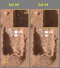
On March 5, 2004, NASA announced that Spirit had found hints of water history on Mars in a rock dubbed “Humphrey”. Raymond Arvidson, the McDonnell University Professor and chair of Earth and planetary sciences at Washington University in St. Louis, reported during a NASA press conference: “If we found this rock on Earth, we would say it is a volcanic rock that had a little fluid moving through it.” In contrast to the rocks found by the twin rover Opportunity, this one was formed from magma and then acquired bright material in small crevices, which look like crystallized minerals. If this interpretation holds true, the minerals were most likely dissolved in water, which was either carried inside the rock or interacted with it at a later stage, after it formed.[76]
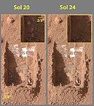
By Sol 390 (Mid-February 2005), as Spirit was advancing towards “Larry’s Lookout”, by driving up the hill in reverse, it investigated some targets along the way, including the soil target, “Paso Robles”, which contained the highest amount of salt found on the red planet. The soil also contained a high amount of phosphorus in its composition, however not nearly as high as another rock sampled by Spirit, “Wishstone”. Squyres said of the discovery, “We’re still trying to work out what this means, but clearly, with this much salt around, water had a hand here”.
As Spirit traveled with a dead wheel in December 2007, pulling the dead wheel behind, the wheel scraped off the upper layer of the Martian soil, uncovering a patch of ground that scientists say shows evidence of a past environment that would have been perfect for microbial life. It is similar to areas on Earth where water or steam from hot springs came into contact with volcanic rocks. On Earth, these are locations that tend to teem with bacteria, said rover chief scientist Steve Squyres. “We’re really excited about this,” he told a meeting of the American Geophysical Union (AGU). The area is extremely rich in silica – the main ingredient of window glass. The researchers have now concluded that the bright material must have been produced in one of two ways. One: hot-spring deposits produced when water dissolved silica at one location and then carried it to another (i.e. a geyser). Two: acidic steam rising through cracks in rocks stripped them of their mineral components, leaving silica behind. “The important thing is that whether it is one hypothesis or the other, the implications for the former habitability of Mars are pretty much the same,” Squyres explained to BBC News. Hot water provides an environment in which microbes can thrive and the precipitation of that silica entombs and preserves them. Squyres added, “You can go to hot springs and you can go to fumaroles and at either place on Earth it is teeming with life – microbial life.[77][78]
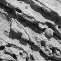
Opportunity was directed to a site that had displayed large amounts of hematite from orbit. Hematite often forms from water. When Opportunity landed, layered rocks and marble-like hematite concretions (“blueberries”) were easily visible. In its years of continuous operation, Opportunity sent back much evidence that a wide area on Mars was soaked in liquid water.
During a press conference in March 2006, mission scientists discussed their conclusions about the bedrock, and the evidence for the presence of liquid water during their formation. They presented the following reasoning to explain the small, elongated voids in the rock visible on the surface and after grinding into it (see last two images below).[79] These voids are consistent with features known to geologists as “vugs”. These are formed when crystals form inside a rock matrix and are later removed through erosive processes, leaving behind voids. Some of the features in this picture are “disk-like”, which is consistent with certain types of crystals, notably sulfate minerals. Additionally, mission members presented first data from the Mössbauer spectrometer taken at the bedrock site. The iron spectrum obtained from the rock El Capitan shows strong evidence for the mineral jarosite. This mineral contains hydroxide ions, which indicates the presence of water when the minerals were formed. Mini-TES data from the same rock showed that it consists of a considerable amount of sulfates. Sulfates also contain water.
-
Close-up of a rock outcrop.
-

Thin Rock layers, not all parallel to each other
-

Section of hole created by RAT
-
Voids or “vugs” inside the rock
Mars Reconnaissance Orbiter[edit]

The Mars Reconnaissance Orbiter’s HiRISE instrument has taken many images that strongly suggest that Mars has had a rich history of water-related processes. A major discovery was finding evidence of hot springs. These may have contained life and may now contain well-preserved fossils of life.
Research, in the January 2010 issue of Icarus, described strong evidence for sustained precipitation in the area around Valles Marineris.[29][30] The types of minerals there are associated with water. Also, the high density of small branching channels indicates a great deal of precipitation because they are similar to stream channels on the Earth.
-

Channels near the rim of Ius Chasma, as seen by HiRISE. The pattern and high density of these channels support precipitation as the source of the water. Location is Coprates quadrangle.
-

Channels in Candor plateau, as seen by HiRISE. Location is Coprates quadrangle. Click on image to see many small, branched channels which are strong evidence for sustained precipitation.
Some places on Mars show inverted relief. In these locations, a stream bed appears as a raised feature, instead of a depression. The inverted former stream channels may be caused by the deposition of large rocks or due to cementation of loose materials. In either case erosion would erode the surrounding land and consequently leave the old channel as a raised ridge because the ridge will be more resistant to erosion. Images below, taken with HiRISE show sinuous ridges that are old channels that have become inverted.[80]
In an article published in January 2010, a large group of scientists endorsed the idea of searching for life in Miyamoto Crater because of inverted stream channels and minerals that indicated the past presence of water.[28][30]
Using data from Mars Global Surveyor, Mars Odyssey and the Mars Reconnaissance Orbiter, scientists have found widespread deposits of chloride minerals. Usually chlorides are the last minerals to come out of solution. A picture below shows some deposits within the Phaethontis quadrangle. Evidence suggests that the deposits were formed from the evaporation of mineral-enriched waters. Lakes may have been scattered over large areas of the Martian surface. Carbonates, sulfates, and silica should precipitate out ahead of them. Sulfates and silica have been discovered by the Mars Rovers. Places with chloride minerals may have once held various life forms. Furthermore, such areas should preserve traces of ancient life.[81]
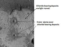
Rocks on Mars have been found to frequently occur as layers, called strata, in many different places. Columbus Crater is one of many craters that contain layers. Rock can form layers in a variety of ways. Volcanoes, wind, or water can produce layers.[82] Many places on Mars show rocks arranged in layers. Scientists are happy about finding layers on Mars since layers may have formed under large bodies of water.
Sometimes the layers display different colors. Light-toned rocks on Mars have been associated with hydrated minerals like sulfates. The Mars rover Opportunity examined such layers close-up with several instruments. Some layers are probably made up of fine particles because they seem to break up into fine dust. In contrast, other layers break up into large boulders so they are probably much harder. Basalt, a volcanic rock, is thought to form layers composed of boulders. Basalt has been identified all over Mars. Instruments on orbiting spacecraft have detected clay (also called phyllosilicates) in some layers.[83][84] Scientists are excited about finding hydrated minerals such as sulfates and clays on Mars because they are usually formed in the presence of water.[85] Places that contain clays and/or other hydrated minerals would be good places to look for evidence of life.[86]
Below are a few of the many examples of layers that have been studied with HiRISE.
-

Close-up of layers in west slope of Asimov Crater. Shadows show the overhang. Some of the layers are much more resistant to erosion, so they stick out. Location is Noachis quadrangle.
-

-
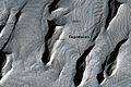
Much of the surface of Mars is covered by a thick smooth mantle that is thought to be a mixture of ice and dust.[87] This ice-rich mantle, a few yards thick, smoothes the land. But in places it displays a bumpy texture, resembling the surface of a basketball. Because there are few craters on this mantle, the mantle is relatively young. The images below, all taken with HiRISE, show a variety of views of this smooth mantle.
-

Niger Vallis with features typical of this latitude. Chevon pattern results from movement of ice-rich material. Click on image to see chevron pattern and mantle. Location is Hellas quadrangle.
-

Atlantis Chaos. Click on image to see mantle covering and possible gullies. The two images are different parts of the original image. They have different scales. Location is Phaethontis quadrangle.
-

Layers in mantle deposit, as seen by HiRISE, under the HiWish program. Mantle was probably formed from snow and dust falling during a different climate. Location is Thaumasia quadrangle.
Changes in Mars’s orbit and tilt cause significant changes in the distribution of water ice from polar regions down to latitudes equivalent to Texas. During certain climate periods water vapor leaves polar ice and enters the atmosphere. The water returns to the ground at lower latitudes as deposits of frost or snow mixed generously with dust. The atmosphere of Mars contains a great deal of fine dust particles.[88] Water vapor condenses on the particles, then they fall down to the ground due to the additional weight of the water coating. When ice at the top of the mantling layer goes back into the atmosphere, it leaves behind dust, which insulates the remaining ice.[54]
HiRISE has carried out many observations of gullies that are assumed to have been caused by recent flows of liquid water. Many gullies are imaged over and over to see if any changes occur. Some repeat observations of gullies have displayed changes that some scientists argue were caused by liquid water over the period of just a few years.[89] Others say the flows were merely dry flows.[90] These were first discovered by the Mars Global Surveyor.
Alternate theories for the creation of surface gullies and channels include wind erosion,[91] liquid carbon dioxide,[92] and liquid methane.[93]
Below are some of the many hundreds of gullies that have been studied with HiRISE.
-

-

Jezza Crater, as seen by HiRISE. North wall (at top) has gullies. Dark lines are dust devil tracks. Scale bar is 500 meters long. Image located in Argyre quadrangle.
-

-

Scalloped Terrain at Peneus Patera. Scalloped terrain is quite common in some areas of Mars.
-
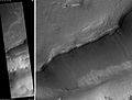
Maunder Crater. The overhang is part of the degraded south (toward bottom) wall of crater. The scale bar is 500 meters long.
-
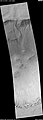
Asimov Crater. Bottom of picture shows southeastern wall of crater. Top of picture is edge of mound that fills most of the crater.
-

Close-up of gullies in crater, as seen by HiRISE under the HiWish program. Location is Phaethontis quadrangle.
-
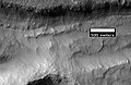
Close-up of gullies in trough, as seen by HiRISE under the HiWish program. These are some of the smaller gullies visible on Mars. Location is Phaethontis quadrangle.
-
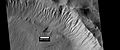
Gullies near Newton Crater, as seen by HiRISE, under the HiWish program. Place where there was an old glacier is labeled. Image from Phaethontis quadrangle.
Of interest from the days of the Viking Orbiters are piles of material surrounding cliffs. These deposits of rock debris are called lobate debris aprons (LDAs). These features have a convex topography and a gentle slope from cliffs or escarpments; this suggests flow away from the steep source cliff. In addition, lobate debris aprons can show surface lineations just as rock glaciers on the Earth.[5] Recently[when?], research with the Shallow Radar on the Mars Reconnaissance Orbiter has provided strong evidence that the LDAs in Hellas Planitia and in mid northern latitudes are glaciers that are covered with a thin layer of rocks. Radar from the Mars Reconnaissance Orbiter gave a strong reflection from the top and base of LDAs, meaning that pure water ice made up the bulk of the formation (between the two reflections).[49][50] Based on the experiments of the Phoenix lander and the studies of the Mars Odyssey from orbit, frozen water is now known to exist at just under the surface of Mars in the far north and south (high latitudes). The discovery of water ice in LDAs demonstrates that water is found at even lower latitudes. Future colonists on Mars will be able to tap into these ice deposits, instead of having to travel to much higher latitudes. Another major advantage of LDAs over other sources of Martian water is that they can easily detected and mapped from orbit. Lobate debris aprons are shown below from the Phlegra Montes, which are at a latitude of 38.2 degrees north. The Phoenix lander set down at about 68 degrees north latitude, so the discovery of water ice in LDAs greatly expands the range of easily available on Mars.[94] It is far easier to land a spaceship near the equator of Mars, so the closer water is available to the equator the better it will be for future colonists.
Below are examples of lobate debris aprons that were studied with HiRISE.
-

Close-up of surface of a lobate debris apron. Note the lines that are common in rock glaciers on the Earth. Image located in Hellas quadrangle.
Research, reported in the journal Science in September 2009,[95] demonstrated that some new craters on Mars show exposed, pure, water ice. After a time, the ice disappears, evaporating into the atmosphere. The ice is only a few feet deep. The ice was confirmed with the Compact Imaging Spectrometer (CRISM) on board the Mars Reconnaissance Orbiter (MRO). The ice was found in five locations. Three of the locations are in the Cebrenia quadrangle. These locations are 55.57° N, 150.62° E; 43.28° N, 176.9° E; and 45° N, 164.5° E. Two others are in the Diacria quadrangle: 46.7° N, 176.8° E and 46.33° N, 176.9° E.[96][97][98]
This discovery proves that future colonists on Mars will be able to obtain water from a wide variety of locations. The ice can be dug up, melted, then taken apart to provide fresh oxygen and hydrogen for rocket fuel. Hydrogen is the powerful fuel used by the Space Shuttle main engines.
Curiosity[edit]
In 2012, the NASA’s rover Curiosity discovered solid evidence for an ancient streambed that used to flow through the rocks.[99] The rover discovered conglomerates, which are rocks made up of sand and gravel. After studying pictures of these rocks, scientists concluded that shape and size of the pebbles that make up the conglomerates signify that they were eroded by water, perhaps several billion years ago. Satellites used to capture evidence of existing channels, which could indicate running water, but did not prove it. This was the first solid major evidence that support these satellite images.
Curiosity carries a meteorological station called REMS (Rover Environmental Monitoring Station). With data from REMS, scientists could in 2015 prove that there are conditions for presence of liquid water on Mars. According to the conclusions, salts in the ground surface on Mars can absorb water vapor from the environment.
The research was presented in Nature Geoscience with Javier Martín-Torres, Professor of Atmospheric Science at Luleå University of Technology as lead author.
See also[edit]
- Seasonal flows on warm Martian slopes
- Evolution of water on Mars and Earth
- Life on Mars (planet)#Liquid water
- Mars#Hydrology
- Atmosphere of Mars#Water vapor
- Geology of Mars#Hydrology
- Mars Express#Scientific discoveries and important events
- Mars Global Surveyor#Discovery of water ice on Mars
- 2001 Mars Odyssey#Water on Mars
- Phoenix (spacecraft)#Presence of shallow subsurface water ice
- Extraterrestrial liquid water
- Mars Ocean Hypothesis
- Colonization of Mars
- Climate of Mars
- Water vapor#Extraterrestrial
- Extraterrestrial life
- Scientific information from the Mars Exploration Rover mission
- Lobate debris apron
- Vallis
- Martian Gullies
- Glacier
References[edit]
- ^ Kreslavsky, M. A; Head, J. W; Arvidson, R. E; Bass, D; Blaney, D; Boynton, W; Carswell, A; Catling, D; Clark, B; Duck, T; Dejong, E; Fisher, D; Goetz, W; Gunnlaugsson, P; Hecht, M; Hipkin, V; Hoffman, J; Hviid, S; Keller, H; Kounaves, S; Lange, C. F; Lemmon, M; Madsen, M; Malin, M; Markiewicz, W; Marshall, J; McKay, C; Mellon, M; Michelangeli, D; et al. (2002). “Mars Exploration: Missions”. Geophysical Research Letters. 29 (15): 1719. Bibcode:2002GeoRL..29.1719K. doi:10.1029/2002GL015392. Retrieved December 19, 2010.
- ^ “ch4”. History.nasa.gov. Retrieved December 19, 2010.
- ^ “ch5”. History.nasa.gov. Retrieved December 19, 2010.
- ^ “ch7”. History.nasa.gov. Retrieved December 19, 2010.
- ^ a b Hugh H. Kieffer (1992). Mars. University of Arizona Press. ISBN 978-0-8165-1257-7. Retrieved March 7, 2011.
- ^ Raeburn, P. 1998. Uncovering the Secrets of the Red Planet Mars. National Geographic Society. Washington D.C.
- ^ Moore, P. et al. 1990. The Atlas of the Solar System. Mitchell Beazley Publishers NY, NY.
- ^ Morton, O. 2002. Mapping Mars. Picador, NY, NY
- ^ a b Arvidson, R; Gooding, James L.; Moore, Henry J. (1989). “The Martian surface as Imaged, Sampled, and Analyzed by the Viking Landers”. Reviews of Geophysics. 27 (1): 39–60. Bibcode:1989RvGeo..27…39A. doi:10.1029/RG027i001p00039.
- ^ Clark, B.; Baird, AK; Rose, HJ Jr.; Toulmin P, 3rd; Keil, K; Castro, AJ; Kelliher, WC; Rowe, CD; Evans, PH (1976). “Inorganic Analysis of Martian Samples at the Viking Landing Sites”. Science. 194 (4271): 1283–1288. Bibcode:1976Sci…194.1283C. doi:10.1126/science.194.4271.1283. PMID 17797084. S2CID 21349024.
- ^ Baird, A.; Toulmin P, 3rd; Clark, BC; Rose Jr, HJ; Keil, K; Christian, RP; Gooding, JL (1976). “Mineralogic and Petrologic Implications of Viking Geochemical Results From Mars: Interim Report”. Science. 194 (4271): 1288–1293. Bibcode:1976Sci…194.1288B. doi:10.1126/science.194.4271.1288. PMID 17797085. S2CID 19232826.
- ^ Hoefen, T.; Clark, RN; Bandfield, JL; Smith, MD; Pearl, JC; Christensen, PR (2003). “Discovery of Olivine in the Nili Fossae Region of Mars”. Science. 302 (5645): 627–630. Bibcode:2003Sci…302..627H. doi:10.1126/science.1089647. PMID 14576430. S2CID 20122017.
- ^ Hamiliton, W.; Christensen, Philip R.; McSween, Harry Y. (1997). “Determination of Martian meteorite lithologies and mineralogies using vibrational spectroscopy”. Journal of Geophysical Research. 102 (E11): 25593–25603. Bibcode:1997JGR…10225593H. doi:10.1029/97JE01874.
- ^ [1][dead link]
- ^ Henderson, Mark (December 7, 2006). “Water has been flowing on Mars within past five years, Nasa says”. The Times. UK. Retrieved March 17, 2007.
- ^ Mars photo evidence shows recently running water. The Christian Science Monitor. Retrieved March 17, 2007
- ^ a b c Malin, Michael C.; Edgett, Kenneth S. (2001). “Mars Global Surveyor Mars Orbiter Camera: Interplanetary cruise through primary mission”. Journal of Geophysical Research. 106 (E10): 23429–23570. Bibcode:2001JGR…10623429M. doi:10.1029/2000JE001455. S2CID 129376333.
- ^ Malin, M. C.; Edgett, Kenneth S. (2000). “Mars Global Surveyor MOC2-1618 Release”. Science. 288 (5475): 2330–2335. Bibcode:2000Sci…288.2330M. doi:10.1126/science.288.5475.2330. PMID 10875910. Retrieved December 19, 2010.
- ^ Malin, M.; Edgett, KS; Posiolova, LV; McColley, SM; Dobrea, EZ (2006). “Present-Day Impact Cratering Rate and Contemporary Gully Activity on Mars”. Science. 314 (5805): 1573–1577. Bibcode:2006Sci…314.1573M. doi:10.1126/science.1135156. PMID 17158321. S2CID 39225477.
- ^ “Changing Mars Gullies Hint at Recent Flowing Water”. SPACE.com. December 6, 2006. Retrieved December 19, 2010.
- ^ “Mars Global Surveyor MOC2-239 Release”. Mars.jpl.nasa.gov. Retrieved December 19, 2010.
- ^ “HiRISE | Slope Streaks in Marte Vallis (PSP_003570_1915)”. Hirise.lpl.arizona.edu. Retrieved December 19, 2010.
- ^ [2][dead link]
- ^ “space.com”. space.com. Archived from the original on November 2, 2010. Retrieved December 19, 2010.
- ^ [3][dead link]
- ^ Malin; Edgett, Kenneth S.; Cantor, Bruce A.; Caplinger, Michael A.; Danielson, G. Edward; Jensen, Elsa H.; Ravine, Michael A.; Sandoval, Jennifer L.; Supulver, Kimberley D. (2010). “An overview of the 1985–2006 Mars Orbiter Camera science investigation”. The Mars Journal. 5: 1–60. Bibcode:2010IJMSE…5….1M. doi:10.1555/mars.2010.0001. S2CID 128873687.
- ^ Zimbelman J, Griffin L (2010). “HiRISE images of yardangs and sinuous ridges in the lower member of the Medusae Fossae Formation, Mars”. Icarus. 205 (1): 198–210. Bibcode:2010Icar..205..198Z. doi:10.1016/j.icarus.2009.04.003.
- ^ a b Newsom, H.; Lanza, Nina L.; Ollila, Ann M.; Wiseman, Sandra M.; Roush, Ted L.; Marzo, Giuseppe A.; Tornabene, Livio L.; Okubo, Chris H.; Osterloo, Mikki M.; Hamilton, Victoria E.; Crumpler, Larry S. (2010). “Inverted channel deposits on the floor of Miyamoto crater, Mars”. Icarus. 205 (1): 64–72. Bibcode:2010Icar..205…64N. doi:10.1016/j.icarus.2009.03.030.
- ^ a b Weitz, C.; Milliken, R.E.; Grant, J.A.; McEwen, A.S.; Williams, R.M.E.; Bishop, J.L.; Thomson, B.J. (2010). “Mars Reconnaissance Orbiter observations of light-toned layered deposits and associated fluvial landforms on the plateaus adjacent to Valles Marineris”. Icarus. 205 (1): 73–102. Bibcode:2010Icar..205…73W. doi:10.1016/j.icarus.2009.04.017.
- ^ a b c Mouginot, J.; Pommerol, A.; Kofman, W.; Beck, P.; Schmitt, B.; Herique, A.; Grima, C.; Safaeinili, A.; Plaut, J.J. (December 2010). “The 3–5MHz global reflectivity map of Mars by MARSIS/Mars Express: Implications for the current inventory of subsurface H2O” (PDF). Icarus. 210 (2): 612–625. Bibcode:2010Icar..210..612M. doi:10.1016/j.icarus.2010.07.003.
- ^ Fairen, A.; Davila, AF; Gago-Duport, L; Amils, R; McKay, CP (2009). “Stability against freezing of aqueous solutions on early Mars”. Nature. 459 (7245): 401–404. Bibcode:2009Natur.459..401F. doi:10.1038/nature07978. PMID 19458717. S2CID 205216655.
- ^ Atmospheric and Meteorological Properties, NASA
- ^ a b Golombek, M.; Cook, RA; Economou, T; Folkner, WM; Haldemann, AF; Kallemeyn, PH; Knudsen, JM; Manning, RM; et al. (1997). “Overview of the Mars Pathfinder Mission and Assessment of Landing Site Predictions”. Science. 278 (5344): 1743–1748. Bibcode:1997Sci…278.1743G. doi:10.1126/science.278.5344.1743. PMID 9388167.
- ^ a b “Mars Odyssey: Newsroom”. Mars.jpl.nasa.gov. May 28, 2002. Retrieved December 19, 2010.
- ^ a b [4][dead link]
- ^ a b Feldman, W. C. (2004). “Global distribution of near-surface hydrogen on Mars”. Journal of Geophysical Research: Planets. 109 (E9): E09006. Bibcode:2004JGRE..109.9006F. doi:10.1029/2003JE002160. S2CID 28825047.
- ^ Murche, S.; et al. (1993). “Spatial Variations in the Spectral Properties of Bright Regions on Mars”. Icarus. 105 (2): 454–468. Bibcode:1993Icar..105..454M. doi:10.1006/icar.1993.1141.
- ^ “Home Page for Bell (1996) Geochemical Society paper”. Marswatch.tn.cornell.edu. Retrieved December 19, 2010.
- ^ Feldman, WC; Boynton, WV; Tokar, RL; Prettyman, TH; Gasnault, O; Squyres, SW; Elphic, RC; Lawrence, DJ; et al. (2002). “Global Distribution of Neutrons from Mars: Results from Mars Odyssey”. Science. 297 (5578): 75–78. Bibcode:2002Sci…297…75F. doi:10.1126/science.1073541. PMID 12040088. S2CID 11829477.
- ^ Mitrofanov, I.; Anfimov, D; Kozyrev, A; Litvak, M; Sanin, A; Tret’yakov, V; Krylov, A; Shvetsov, V; et al. (2002). “Maps of Subsurface Hydrogen from the High Energy Neutron Detector, Mars Odyssey”. Science. 297 (5578): 78–81. Bibcode:2002Sci…297…78M. doi:10.1126/science.1073616. PMID 12040089. S2CID 589477.
- ^ Boynton, W.; Feldman, WC; Squyres, SW; Prettyman, TH; Bruckner, J; Evans, LG; Reedy, RC; Starr, R; et al. (2002). “Distribution of Hydrogen in the Near Surface of Mars: Evidence for Subsurface Ice Deposits”. Science. 297 (5578): 81–85. Bibcode:2002Sci…297…81B. doi:10.1126/science.1073722. PMID 12040090. S2CID 16788398.
- ^ a b Arvidson, P. H.; Tamppari, L.; Arvidson, R. E.; Bass, D.; Blaney, D.; Boynton, W.; Carswell, A.; Catling, D.; Clark, B.; Duck, T.; Dejong, E.; Fisher, D.; Goetz, W.; Gunnlaugsson, P.; Hecht, M.; Hipkin, V.; Hoffman, J.; Hviid, S.; Keller, H.; Kounaves, S.; Lange, C. F.; Lemmon, M.; Madsen, M.; Malin, M.; Markiewicz, W.; Marshall, J.; McKay, C.; Mellon, M.; Michelangeli, D.; et al. (2008). “Introduction to special section on the phoenix mission: Landing site characterization experiments, mission overviews, and expected science” (PDF). Journal of Geophysical Research. 113 (E12): E00A18. Bibcode:2008JGRE..113.0A18S. doi:10.1029/2008JE003083. hdl:2027.42/94752.
- ^ “The Dirt on Mars Lander Soil Findings”. SPACE.com. Retrieved December 19, 2010.
- ^ Irwin, Rossman P.; Howard, Alan D.; Craddock, Robert A.; Moore, Jeffrey M. (2005). “An intense terminal epoch of widespread fluvial activity on early Mars: 2. Increased runoff and paleolake development”. Journal of Geophysical Research. 110 (E12): E12S15. Bibcode:2005JGRE..11012S15I. CiteSeerX 10.1.1.455.4088. doi:10.1029/2005JE002460.
- ^ Head, J.; Neukum, G.; Jaumann, R.; Hiesinger, H.; Hauber, E.; Carr, M.; Masson, P.; Foing, B.; et al. (2005). “Tropical to mid-latitude snow and ice accumulation, flow and glaciation on Mars”. Nature. 434 (7031): 346–350. Bibcode:2005Natur.434..346H. doi:10.1038/nature03359. PMID 15772652. S2CID 4363630.
- ^ “Mars’ climate in flux: Mid-latitude glaciers | Mars Today – Your Daily Source of Mars News”. Mars Today. October 17, 2005. Archived from the original on December 5, 2012. Retrieved December 19, 2010.
- ^ Richard Lewis (April 23, 2008). “Glaciers Reveal Martian Climate Has Been Recently Active | Brown University Media Relations”. News.brown.edu. Retrieved December 19, 2010.
- ^ a b Plaut, Jeffrey J.; Safaeinili, Ali; Holt, John W.; Phillips, Roger J.; Head, James W.; Seu, Roberto; Putzig, Nathaniel E.; Frigeri, Alessandro (2009). “Radar Evidence for Ice in Lobate Debris Aprons in the Mid-Northern Latitudes of Mars” (PDF). Geophysical Research Letters. 36 (2): n/a. Bibcode:2009GeoRL..3602203P. doi:10.1029/2008GL036379. S2CID 17530607. Archived from the original (PDF) on 2021-01-23. Retrieved 2011-09-01.
- ^ a b c Holt, J. W.; Safaeinili, A.; Plaut, J. J.; Young, D. A.; Head, J. W.; Phillips, R. J.; Campbell, B. A.; Carter, L. M.; Gim, Y.; Seu, R.; Sharad Team (2008). “Radar Sounding Evidence for Ice within Lobate Debris Aprons near Hellas Basin, Mid-Southern Latitudes of Mars” (PDF). Lunar and Planetary Science. XXXIX (1391): 2441. Bibcode:2008LPI….39.2441H.
- ^ a b Plaut, Jeffrey J.; Safaeinili, Ali; Holt, John W.; Phillips, Roger J.; Head, James W.; Seu, Roberto; Putzig, Nathaniel E.; Frigeri, Alessandro (2009). “Radar evidence for ice in lobate debris aprons in the mid-northern latitudes of Mars” (PDF). Geophysical Research Letters. 36 (2): n/a. Bibcode:2009GeoRL..3602203P. doi:10.1029/2008GL036379. S2CID 17530607. Archived from the original (PDF) on 2021-01-23. Retrieved 2011-09-01.
- ^ “Reull Vallis (Released 22 October 2002) | Mars Odyssey Mission THEMIS”. Themis.asu.edu. Archived from the original on 17 June 2010. Retrieved December 19, 2010.
- ^ Mustard, J.; Cooper, CD; Rifkin, MK (2001). “Evidence for recent climate change on Mars from the identification of youthful near-surface ground ice”. Nature. 412 (6845): 411–414. Bibcode:2001Natur.412..411M. doi:10.1038/35086515. PMID 11473309. S2CID 4409161.
- ^ Kreslavsky, M. A.; Head, J. W. (2002). “Mars: Nature and evolution of young latitude-dependent water-ice-rich mantle”. Geophysical Research Letters. 29 (15): 14–1. Bibcode:2002GeoRL..29.1719K. doi:10.1029/2002GL015392.
- ^ a b MLA NASA/Jet Propulsion Laboratory (2003, December 18). Mars May Be Emerging From An Ice Age. ScienceDaily. Retrieved February 19, 2009, from https://www.sciencedaily.com/releases/2003/12/031218075443.htmAds[permanent dead link] by GoogleAdvertise
- ^ “Dao Vallis (Released 7 August 2002) | Mars Odyssey Mission THEMIS”. Themis.asu.edu. Retrieved December 19, 2010.
- ^ Mellon M, Jakosky B (1993). “Geographic variations in the thermal and diffusive stability of ground ice on Mars”. Journal of Geophysical Research. 98 (E2): 3345–3364. Bibcode:1993JGR….98.3345M. doi:10.1029/92JE02355.
- ^ a b Bright Chunks at Phoenix Lander’s Mars Site Must Have Been Ice – Official NASA press release (June 19, 2008)
- ^ Rayl, A. j. s. (June 21, 2008). “Phoenix Scientists Confirm Water-Ice on Mars”. The Planetary Society web site. Planetary Society. Archived from the original on June 27, 2008. Retrieved June 23, 2008.
- ^ “Confirmation of Water on Mars”. Nasa.gov. June 20, 2008. Retrieved December 19, 2010.
- ^ Johnson, John (August 1, 2008). “There’s water on Mars, NASA confirms”. Los Angeles Times. Retrieved August 1, 2008.
- ^ Heldmann, Jennifer L. (May 7, 2005). “Formation of Martian gullies by the action of liquid water flowing under current Martian environmental conditions” (PDF). Journal of Geophysical Research. 110: Eo5004. Bibcode:2005JGRE..11005004H. CiteSeerX 10.1.1.596.4087. doi:10.1029/2004JE002261. hdl:2060/20050169988. S2CID 1578727. Archived from the original (PDF) on October 1, 2008. Retrieved September 14, 2008. ‘conditions such as now occur on Mars, outside of the temperature-pressure stability regime of liquid water’ … ‘Liquid water is typically stable at the lowest elevations and at low latitudes on the planet because the atmospheric pressure is greater than the vapor pressure of water and surface temperatures in equatorial regions can reach 273 K for parts of the day [Haberle et al., 2001]’
- ^ Kostama, V.-P.; et al. (June 3, 2006). “Recent high-latitude icy mantle in the northern plains of Mars: Characteristics and ages of emplacement”. Geophysical Research Letters. 33 (11): L11201. Bibcode:2006GeoRL..3311201K. CiteSeerX 10.1.1.553.1127. doi:10.1029/2006GL025946. S2CID 17229252. Retrieved August 12, 2007. ‘Martian high-latitude zones are covered with a smooth, layered ice-rich mantle’
- ^ Hecht, MH; Kounaves, SP; Quinn, RC; West, SJ; Young, SM; Ming, DW; Catling, DC; Clark, BC; et al. (2009). “Detection of Perchlorate and the Soluble Chemistry of Martian Soil at the Phoenix Lander Site”. Science. 325 (5936): 64–67. Bibcode:2009Sci…325…64H. doi:10.1126/science.1172466. PMID 19574385. S2CID 24299495.
- ^ a b c Chang, Kenneth (2009) Blobs in Photos of Mars Lander Stir a Debate: Are They Water?, The New York Times (online), March 16, 2009. Retrieved April 4, 2009;
- ^ “Los Angeles Times article”.[dead link]
- ^ “Astrobiology Top 10: Too Salty to Freeze”. Astrobiology Magazine. Archived from the original on 2011-06-29. Retrieved December 19, 2010.
{{cite web}}: CS1 maint: unfit URL (link) - ^ “Liquid Saltwater Is Likely Present On Mars, New Analysis Shows”. Sciencedaily.com. 2009-03-20. Retrieved 2011-08-20.
- ^ Kessler, Andrew (2011). Martian Summer: Robot Arms, Cowboy Spacemen, and My 90 Days with the Phoenix Mars Mission. ISBN 978-1-60598-176-5.
- ^ Rennó, Nilton O.; Bos, Brent J.; Catling, David; Clark, Benton C.; Drube, Line; Fisher, David; Goetz, Walter; Hviid, Stubbe F.; Keller, Horst Uwe; Kok, Jasper F.; Kounaves, Samuel P.; Leer, Kristoffer; Lemmon, Mark; Madsen, Morten Bo; Markiewicz, Wojciech J.; Marshall, John; McKay, Christopher; Mehta, Manish; Smith, Miles; Zorzano, M. P.; Smith, Peter H.; Stoker, Carol; Young, Suzanne M. M. (2009). “Possible physical and thermodynamical evidence for liquid water at the Phoenix landing site” (PDF). Journal of Geophysical Research. 114 (E1): E00E03. Bibcode:2009JGRE..114.0E03R. doi:10.1029/2009JE003362. hdl:2027.42/95444.
- ^ Smith, PH; Tamppari, LK; Arvidson, RE; Bass, D; Blaney, D; Boynton, WV; Carswell, A; Catling, DC; et al. (2009). “H2O at the Phoenix Landing Site”. Science. 325 (5936): 58–61. Bibcode:2009Sci…325…58S. doi:10.1126/science.1172339. PMID 19574383. S2CID 206519214.
- ^ “The Dirt on Mars Lander Soil Findings”. Space.com. Retrieved December 19, 2010.
- ^ Witeway, J.; Komguem, L; Dickinson, C; Cook, C; Illnicki, M; Seabrook, J; Popovici, V; Duck, TJ; et al. (2009). “Mars Water-Ice Clouds and Precipitation”. Science. 325 (5936): 68–70. Bibcode:2009Sci…325…68W. CiteSeerX 10.1.1.1032.6898. doi:10.1126/science.1172344. PMID 19574386. S2CID 206519222.
- ^ “CSA – News Release”. Asc-csa.gc.ca. July 2, 2009. Archived from the original on July 5, 2011. Retrieved December 19, 2010.
- ^ Boynton, WV; Ming, DW; Kounaves, SP; Young, SM; Arvidson, RE; Hecht, MH; Hoffman, J; Niles, PB; et al. (2009). “Evidence for Calcium Carbonate at the Mars Phoenix Landing Site”. Science. 325 (5936): 61–64. Bibcode:2009Sci…325…61B. doi:10.1126/science.1172768. PMID 19574384. S2CID 26740165.
- ^ “Audio Recording of Phoenix Media Telecon for Aug. 5, 2008”. Jet Propulsion Laboratory. NASA. August 5, 2008. Retrieved July 14, 2009.
- ^ “Mars Exploration Rover Mission: Press Releases”. Marsrovers.jpl.nasa.gov. March 5, 2004. Retrieved December 19, 2010.
- ^ Amos, Jonathan (December 11, 2007). “Mars robot unearths microbe clue”. NASA says its robot rover Spirit has made one of its most significant discoveries on the surface of Mars. Retrieved December 12, 2007.
- ^ Bertster, Guy (December 10, 2007). “Mars Rover Investigates Signs of Steamy Martian Past”. Press Release. Jet Propulsion Laboratory, Pasadena, California. Retrieved December 12, 2007.
- ^ “Opportunity Rover Finds Strong Evidence Meridiani Planum Was Wet”. Retrieved July 8, 2006.
- ^ “HiRISE | Sinuous Ridges Near Aeolis Mensae”. Hiroc.lpl.arizona.edu. January 31, 2007. Archived from the original on March 5, 2016. Retrieved December 19, 2010.
- ^ Osterloo, MM; Hamilton, VE; Bandfield, JL; Glotch, TD; Baldridge, AM; Christensen, PR; Tornabene, LL; Anderson, FS (2008). “Chloride-Bearing Materials in the Southern Highlands of Mars”. Science. 319 (5870): 1651–1654. Bibcode:2008Sci…319.1651O. CiteSeerX 10.1.1.474.3802. doi:10.1126/science.1150690. PMID 18356522. S2CID 27235249.
- ^ “HiRISE | High Resolution Imaging Science Experiment”. Hirise.lpl.arizona.edu?psp_008437_1750. Retrieved December 19, 2010.
- ^ [5][dead link]
- ^ “Articles | Was there life on Mars? – ITV News”. Itv.com. Archived from the original on June 6, 2011. Retrieved December 19, 2010.
- ^ “Target Zone: Nilosyrtis? | Mars Odyssey Mission THEMIS”. Themis.asu.edu. Retrieved December 19, 2010.
- ^ “Craters and Valleys in the Elysium Fossae (PSP_004046_2080)”. Hirise.lpl.arizona.edu. Retrieved 2011-08-20.
- ^ Head, James W.; Mustard, John F.; Kreslavsky, Mikhail A.; Milliken, Ralph E.; Marchant, David R. (2003). “Recent ice ages on Mars”. Nature. 426 (6968): 797–802. Bibcode:2003Natur.426..797H. doi:10.1038/nature02114. PMID 14685228. S2CID 2355534.
- ^ Head, J. et al. 2008. Formation of gullies on Mars: Link to recent climate history and insolation microenvironments implicate surface water flow origin. PNAS: 105. 13258-13263.
- ^ Malin, M.; Edgett, KS; Posiolova, LV; McColley, SM; Dobrea, EZ (2006). “Present-day impact cratering rate and contemporary gully activity on Mars”. Science. 314 (5805): 1573–1577. Bibcode:2006Sci…314.1573M. doi:10.1126/science.1135156. PMID 17158321. S2CID 39225477.
- ^ Kolb, K.; Pelletier, Jon D.; McEwen, Alfred S. (2010). “Modeling the formation of bright slope deposits associated with gullies in Hale Crater, Mars: Implications for recent liquid water”. Icarus. 205 (1): 113–137. Bibcode:2010Icar..205..113K. doi:10.1016/j.icarus.2009.09.009.
- ^ Leovy, C.B. (1999). “Wind and climate on Mars”. Science. 284 (5422): 1891. doi:10.1126/science.284.5422.1891a.
- ^ Read, Peter L.; Lewis, S. R. (2004). The Martian Climate Revisited: Atmosphere and Environment of a Desert Planet. Chichester, UK: Praxis. ISBN 978-3-540-40743-0. Archived from the original (Paperback) on July 24, 2011. Retrieved December 19, 2010.
- ^ Tang Y, Chen Q, Huang Y (2006). “Early Mars may have had a methanol ocean”. Icarus. 181 (1): 88–92. Bibcode:2006Icar..180…88T. doi:10.1016/j.icarus.2005.09.013.
- ^ “Space Topics: Phoenix”. The Planetary Society. Archived from the original on August 22, 2011. Retrieved September 1, 2011.
- ^ Byrne, S; Dundas, CM; Kennedy, MR; Mellon, MT; McEwen, AS; Cull, SC; Daubar, IJ; Shean, DE; et al. (2009). “Distribution of mid-latitude ground ice on Mars from new impact craters”. Science. 325 (5948): 1674–1676. Bibcode:2009Sci…325.1674B. doi:10.1126/science.1175307. PMID 19779195. S2CID 10657508.
- ^ “Water Ice Exposed in Mars Craters”. SPACE.com. Retrieved December 19, 2010.
- ^ “NASA Spacecraft Sees Ice on Mars Exposed by Meteor Impacts”. 2009-09-24. Archived from the original on October 26, 2009. Retrieved September 1, 2011.
- ^ NASA.gov[dead link]
- ^ “Mars images ‘show old streambed’“. BBC News. September 27, 2012.
